 World of O News
One of the absolute highlights in this year’s edition: CISM Long in Korea with a complex leg with many route choice options. Today’s leg in Route to Christmas is leg 2 in the Long course from CISM Long 2015 at October 8th 2015.
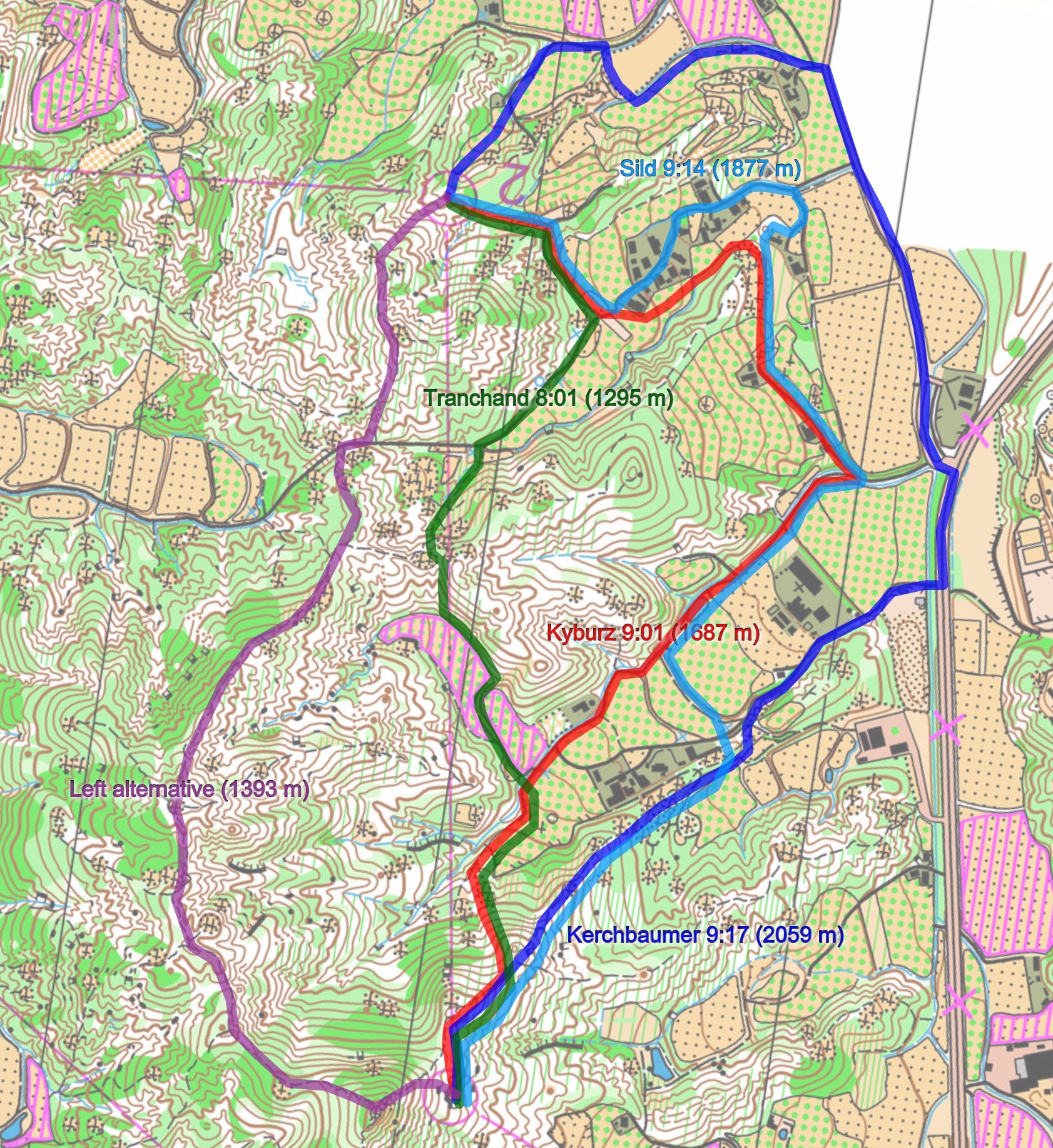
About 1000 meters of climbing!!! 8.9 km straight but 13-14 km of running (Gernot Kerschbaumer)
Thanks to the organizers’ Harald Østbye for providing the map and the tip about the course, and to Matthias Kyburz (1st), Gernot Kerschbaumer (2nd), Frederic Tranchand (3rd) and Timo Sild (10th) for providing their routes on the leg (there is no GPS-data available here).
Slow and tough
With 8.9 kilometer course length and 630 meter climb, the course in CISM Long did not look too tough on paper. This was however extremely tough and slow terrain, and according to Gernot Kerschbaumer’s map archive he ran 13-14 km with about 1000 meters of climb. This should be a good backdrop when considering your route. This is not a terrain where you run straight on the compass Gustav-Bergman style.
The chosen leg is the second leg. As Kyburz put it: – I think leg 1-2 is quite cool. There are many options. The leg is as usually first provided without routes – you may take a look at it and think about how you would attack this leg (if the image is too small, you may click on it to get it larger):
![]()
Location
You find other maps from the area in omaps.worldofo.com here. See also latest additions in 3DRerun from this area in order to learn more about this terrain type.
Webroute
Next you can draw your own route using the ‘Webroute’ below. Think through how you would attack this leg, and draw the route you would have made. Some comments about why you would choose a certain route are always nice for the other readers.
Then you can take a look at how the runners have solved this leg below. As you can see four of the runners whose route is available chose to take different options around to the right. Kyburz, the winner of the race, is fastest of them with 9:01 (red route). Note however that Kyburz lost some time around the middle of the leg,
– I lost quite much time because after running down the big road and after the small cementaries I was stuck in hedge which was not mapped and had to do a detour. Going down and then up again along the field.
Density map
See below for a density map of some of the ones who have drawn their routes so far.

Additional information
You find the complete map in omaps.worldofo.com at this location.
Route to Christmas series
The Route to Christmas series at World of O has been very popular the last years – giving the readers the opportunity to do one Route Choice Challenge each day from December 1st until December 24th. If you have got any good legs in RouteGadget, GPSSeuranta or 3DRerun from 2015-competitions – or old forgotten ones which are still interesting – please email me the link at Jan@Kocbach.net, and I’ll include it in Route to Christmas if it looks good. Route to Christmas will not be interesting if YOU don’t contribute.
Not all legs are taken for the interesting routechoice alternatives – some are also taken because the map is interesting – or because it is not straightforward to see what to do on a certain leg. Any comments are welcome – especially if you ran the event chosen for todays leg!


Hmm, the big road on the right is prohibited area … looks like somebody should have been disqualified here, or ….?
No, because the road itself is not prohibited area (but the fields beside it)
There are purple X markings on either side of a portion of the blue road route. X doesn’t mean “area next to path forbidden”.
What area belongs to the street and where begins the area next to it?
Here the steet is forbidden and the area next to it marked green so it seems not to be a good route choise to go there.