 World of O News

3DRerun: Orienteering Analysis the Fun way. And cool visualization! And a lot more than that as well! After more than a year of development 3DRerun is now open for YOU to use! Thanks to elite orienteers, national teams and others who have given valuable feedback, 3DRerun has now entered open beta testing.
Open beta testing means that there is still some development to be done, but 3DRerun is now considered to be up to a standard which makes it usable and ready for a larger user base. Please provide feedback as a comment below if you have problems using 3DRerun, or if you have suggestions for improvements.
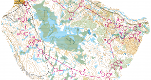
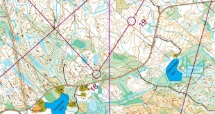
Below is an example of what you can easily do in 3DRerun (example from 10Mila 2010 – open it in 3DRerun here). After setting up a user in 3DRerun, you can make similar analysis with your own GPS data. Several national teams have used 3DRerun this way to analyze their training camps.
3DRerun example from 10Mila 2010. Click here to replay in 3DRerun yourself.
This post will be followed up by articles at World of O and o-training.net on how to use 3DRerun for analysis and other purposes the coming weeks.
- Head over to the 3DRerun start page
- Videos with instructions on how to use 3DRerun (see a few of them below)
- 3DRerun demo videos
- Note! You need to register with email-address/password in order to upload maps/routes to 3DRerun – this is a anti-spam measure. Please check your spam-folder if you don’t receive an email after registering.
As of now there are 23.000 routes/maps in 3DRerun. A majority of these are directly imported from omaps.worldofo.com – using the fact that maps exported from QuickRoute have GPS-data embedded for the calibration. Note that many of these maps are not accurately calibrated due to people using many calibration points in QuickRoute when adjusting map/route. Check out the intro-video at the bottom of this page to see how to adjust you map/route to get the best performance in 3DRerun.
Note! 3DRerun works best in the Google Chrome browser – but should also work in Internet Explorer (from version 7 and up) and in Firefox (from version 3 – note however some problems in Firefox 4). Please report problems in any of the browsers.
HowTo: Your first 3DRerun analysis
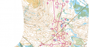
This screencast takes you through a simple analysis in 3DRerun. The sample case is test races for WOC 2011 in the Annecy-area in France. Four maps/routes which are already in 3DRerun are used for the analysis. The screencast takes you through opening the routes, changing background map, starting/stopping the animation, changing animation speed, making an analysis on a simple leg by introducing control points, and doing a simple chrono-analysis.
HowTo: Add your own maps from QuickRoute
This screencast takes you through how to prepare and upload your own maps to 3DRerun. The sample case is a local race in Bergen. It also takes you through some simple analysis.
Thanks to those of you sending in issues/problems. I’ve noted the following so far:
– Problems with calibration calculation for some maps from New Zealand – somehow I calculate the wrong rotation angle.
– Problems in import of routes in some events from GPSSeuranta (some of the new events where format is changed)
Please post any other issues you have so I can take a look at them.