 World of O News
Today is your lucky day! Not one, but two(!) very interesting legs from Croatia are on offer in Route to Christmas today. And the legs offer very different orienteering challenges: Although significant parts of the map are extreme karst, the other part is more typical continental terrain, and the course setter did set the course in such a way a mix of capabilities is definitely also asked for.
The course setter did set the course in such a way that a mix of capabilities is definitely also asked for
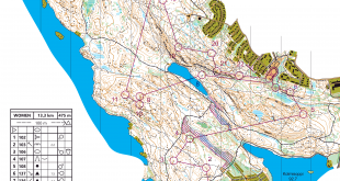
Todays legs in Route to Christmas are from Croatia Open Day 4 at July 27th 2012 in the Croatian region Gorski kotar close to Crni lug – a long distance race. We offer two legs – first a short one, and then a long one (I guess only half of you will take enough time off work to draw routes on both of them:). Thanks a lot to the organizer of Croatia Open for providing the legs (and even drawing the routes in OCAD based on routes collected from the runner after the race). BTW: Croatia Open is also one of the sponsors of Achievement of the Year, but legs from Croatia Open appearing here in Route to Christmas are purely based on the quality of the routes & legs (so why not use the opportunity to get some attention to your event if you had some great route choice legs in this year’s edition of your event?).
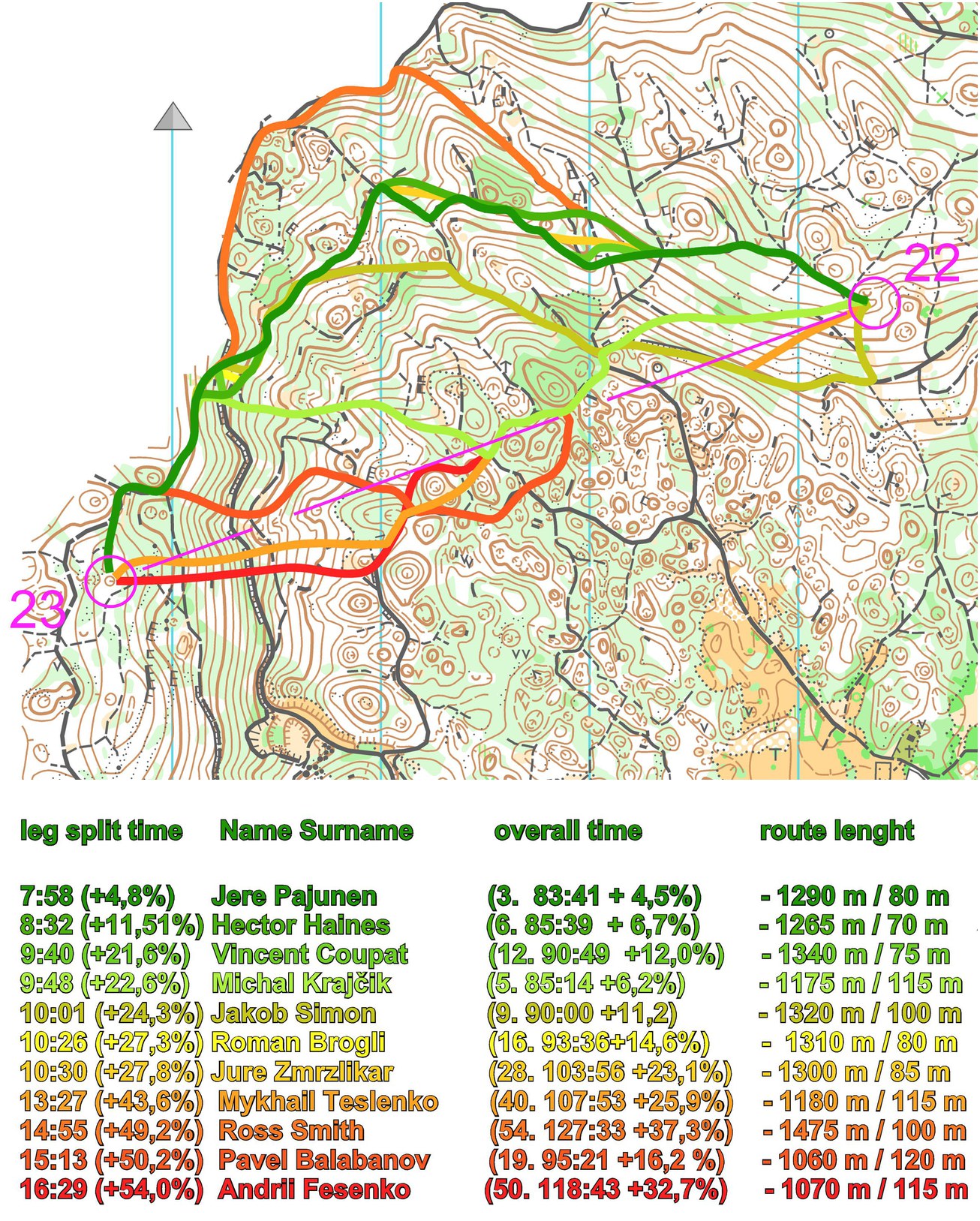
The leg is in the last part of the course – from control 22 to 23. It is set on steep slope with many depressions. This is karst terrain – runnability is not the best in the depressions. The leg is as usually first provided without routes – you may take a look at it and think about how you would attack this leg (if the image is too small, you may click on it to get it larger):
![]()
Location
You find other maps from the area in omaps.worldofo.com here. See also latest additions in 3DRerun from this area in order to learn more about this terrain type.
Webroute
Next you can draw your own route using the ‘Webroute’ below. Think through how you would attack this leg, and draw the route you would have made. Some comments about why you would choose a certain route are always nice for the other readers.
Then you can take a look at how the runners who have drawn their route choice solved this leg below.

Comments
Most of the runners were tired on this part of course (winning time was impressive 79:57 by Stig Alvestad, Norway) and this was their last tricky route choice on the day.
At first sight, it might not be too easy to see that you have to run a lot down to come down to the plateau with the depressions
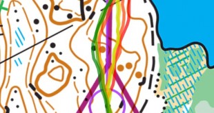
Above you see two illustrations for the “solution” on this leg. The first one is the one provided by the organizer showing leg times for the runners who drew their route after the race. This does, however, not include the winner Stig Alvestad – but he has provided a GPS track of his route which is included in a separate illustration. I compared the route with another runner who has uploaded his GPS – Janus Tamusz (enjoy a style study of Janus from OOcup here).
At first sight, it might not be too easy to see that you have to run a lot down to come down to the plateau with the depressions – and you need to climb all of it up again. The depression plateau just looks so tempting! However, that’s not the solution you are looking for! As you can see from the upper illustration, the best solution was to not loose altitude unnecessarily – you will suffer a lot for that when facing a tough climb of 100 meters climbing on this relatively short 320 meter long leg. Michal Krajčik and Pavel Balabanov both lost some minutes here. And as you see from the lower illustration, Stig Alvestad also looses a minute.
The question for you: Do you often loose concentration in last part of course and how do you handle it?
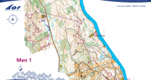
Second leg
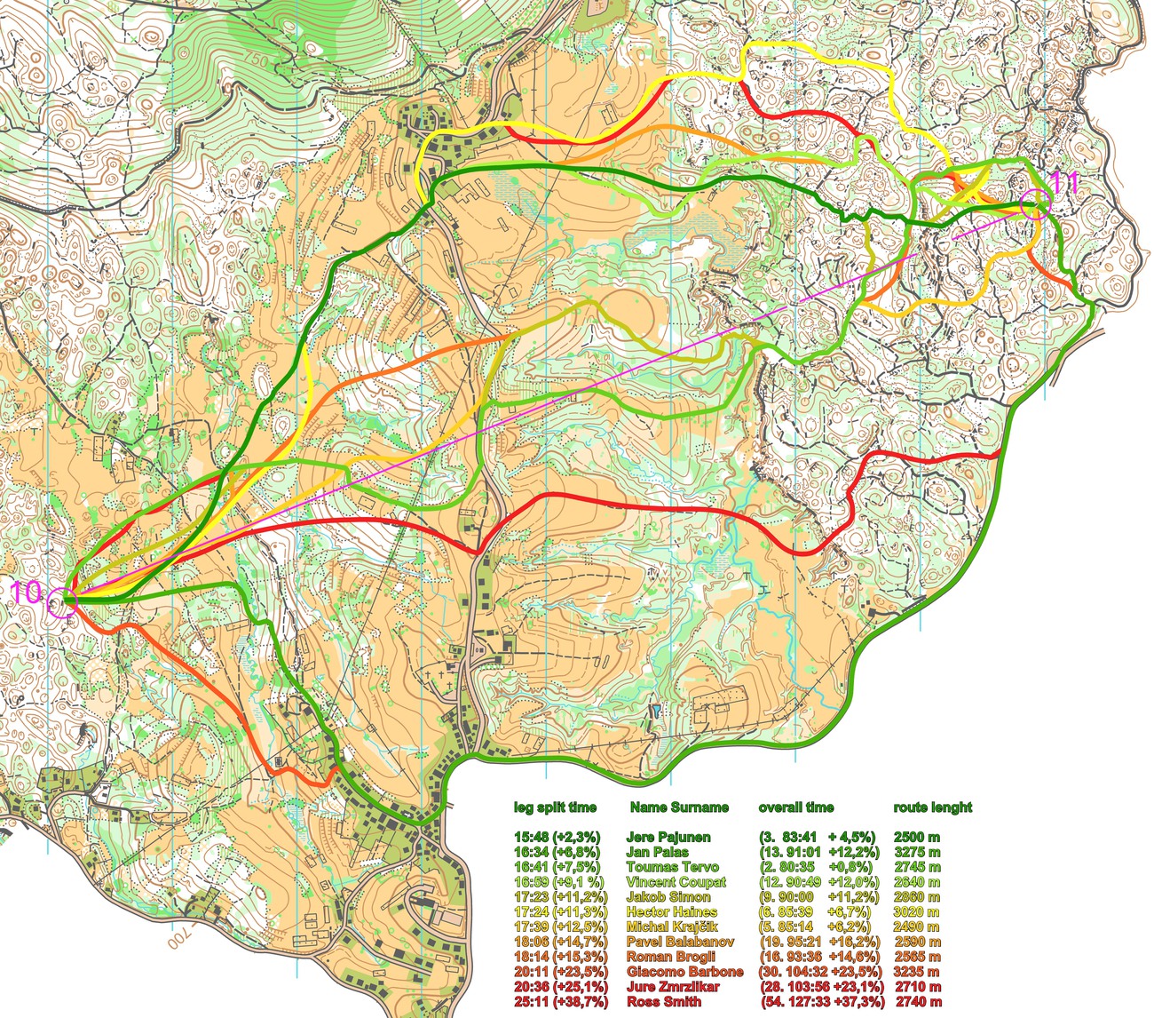
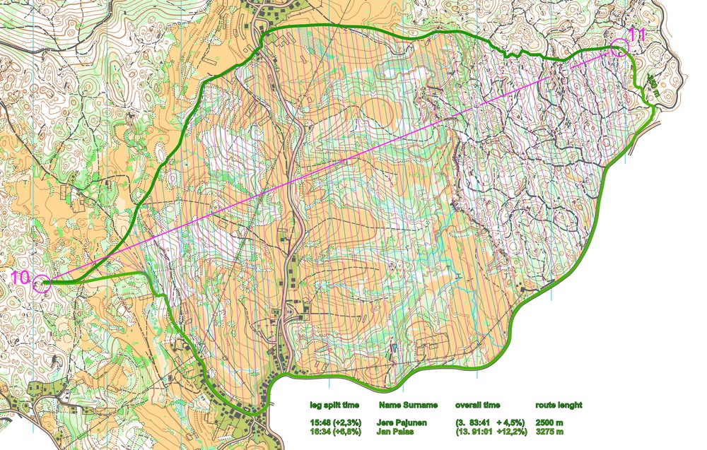
The second leg on offer is a long one! Again the leg is as usually first provided without routes:
![]()
Webroute
Next you can draw your own route using the ‘Webroute’ below. Think through how you would attack this leg, and draw the route you would have made. Some comments about why you would choose a certain route are always nice for the other readers.
Then you can take a look at how the runners who have drawn their route choice solved this leg below.

Comments
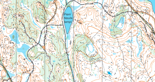
There are three main options for this leg:
- The straight route – approximately 2600 meter long for Stig Alvestad’s choice. Stig Alvestad is not in the overview from the organizers – but he is actually som seconds faster than all the others here (based on the GPS time).
- The 800 meter longer southern route provides a safe route choice covered with more than 90% running on paths and roads – but a very long detour. Both Jan Palas and Pavel Balabanov gained time comparing to their overall time with this “safe” route. Update: Note that according to the comments below, Palas lost 60-80 seconds on the last part of the route on a mistake.
- Northern route choice. Both Jere Pajunen and Vincent Coupat earned time compared to their overall time while running the northern route-choice.
According to the organizers, it is most likely that northern route choice is a bit faster – but they did not have the route of Alvestad. When including the route of Alvestad, I would say the direct and the northern may be quite similar in time. Update: Based on the comment from Palas, I guess we have to completely change the conclusion (that’s how it is when trying to analyze without GPS-data – luckily we usually have GPS-data here in Route to Christmas these days:). Thanks a lot Jan, for your comment!
The question for you: Do you prefer more running on terrain or on paths and roads while solving long legs?
Additional information
You find the complete map in omaps.worldofo.com at this location.
Route to Christmas series
The ‘Route to Christmas’ series at World of O has been very popular the last years – and I have therefore decided to continue the series this Christmas as well. If you have got any good legs in RouteGadget, GPSSeuranta or 3DRerun from 2012-competitions – or old forgotten ones which are still interesting – please email me the link at Jan@Kocbach.net, and I’ll include it in Route to Christmas if it looks good. Route to Christmas will not be interesting if YOU don’t contribute.
Not all legs are taken for the interesting routechoice alternatives – some are also taken because the map is interesting – or because it is not straightforward to see what to do on a certain leg. Any comments are welcome – especially if you ran the event chosen for todays leg!
Note that there may be some errors in the Routegadget data (sometimes somebody draws a route for another runner just for fun). Please add a comment below if you spot en error.
About 2nd route choice: There is a slight mistake in drawing of my route choice – I made a mistake in the very last part of the leg (last 200m) which cost me about 60-80sec. Knowing this, I think my route choice was clearly the fastest route for this leg.
Thanks a lot for your comment, Jan! Very helpful. You don’t by any chance have a GPS-track from your race?
You are welcome! Unfortunatelly, bateries in my GPS went out during the race (before the leg, of course…) so I cannot help…sorry. (Just a bad luck – I have GPS records from almost all races from the whole season :-( )
Nice to see my routes included! However, these were not my best races physically to say the least.
In first route choice it can be seen that I lose 120 seconds in one place – I was actually very confused about the roads there – something didn’t match the map.
In the second route-choice i believe the southern choice to be totally safe while on mine I lost time in the last part, going through green uphill and running too much around, using roads. Also, generally running much slower than mentioned orienteers.
The last part of this leg (after the open areas) was very tricky with quite bad runability in the forest. I think that may be why Palas was so fast going around.
Palas’ route choice could probably faster in the first third of the leg by crossing the open fields to the small graveyard instead of going around (?).
Yeah, that was the plan, however I got little bit confused in open fields and when I realized that, it was better to do it the way I run the leg instead of switching to the initially planned. Thus you can consider first part of my leg as another small mistake :-)
I’ve noticed few comments for my route, but want to add one more thing.
Tristan Bloemen in M18 did 15:36 on similar route. They had this on very beginning (from start point to #41 (11th in M21E)), what is a bit longer route, but maybe easier to choose to go on the road.