 World of O News
The first day of Route to Christmas 2014 takes us to Norway – to one of the nominated courses for “Course of the Year 2014″ – the World Cup Long distance in Kongsberg.
The chosen leg this time is the 16th leg in the men’s course – the most challenging route choice leg in the race which was quite decisive for the overall outcome of the race. Remember the setting: Arriving at control 15 you are tired – really tired. Next up is a long leg – and you see a really tough hill up to the control. Should you climb that tough hill into the control, or should you rather go left and take the control from behind from the road and save some power for the last part of the leg? But on the other hand there are quite some hills at the first part of the leg on the the leftmost alternative. What would you choose?
The leg is as usually first provided without routes – you may take a look at it and think about how you would attack this leg (if the image is too small, you may click on it to get it larger). Note that there are no “realistic” route choices further to the right than what you see in the map below – so don’t bother about that…
![]()
Location
You find other maps from the area in omaps.worldofo.com here. See also latest additions in 3DRerun from this area in order to learn more about this terrain type.
Webroute
Next you can draw your own route using the ‘Webroute’ below. Think through how you would attack this leg, and draw the route you would have made. Some comments about why you would choose a certain route are always nice for the other readers.
Then you can take a look at how the runners have solved this leg below. As you can see, the only way to go here was to be tough and take the hill. William Lind going right has the fastest split (these are official split times from Winsplits).

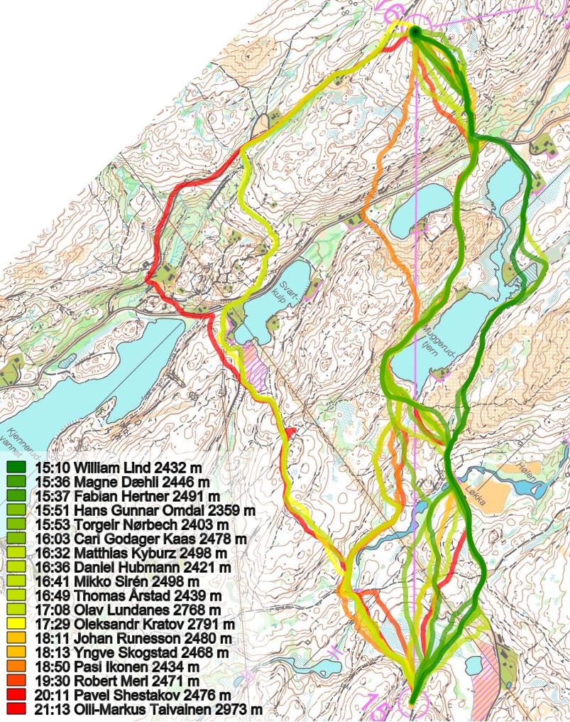
Density map
See below for a density map of some of the ones who have drawn their routes so far.

Comments
Additional information
You find the complete map in omaps.worldofo.com at this location.
Route to Christmas series
The Route to Christmas series at World of O has been very popular the last years – and I have therefore decided to continue the series this Christmas as well. If you have got any good legs in RouteGadget, GPSSeuranta or 3DRerun from 2014-competitions – or old forgotten ones which are still interesting – please email me the link at Jan@Kocbach.net, and Ill include it in Route to Christmas if it looks good. Route to Christmas will not be interesting if YOU dont contribute.
Not all legs are taken for the interesting routechoice alternatives – some are also taken because the map is interesting – or because it is not straightforward to see what to do on a certain leg. Any comments are welcome – especially if you ran the event chosen for todays leg!
Note that there may be some errors in the Routegadget data (sometimes somebody draws a route for another runner just for fun). Please add a comment below if you spot en error.


Is the fastest route by Lind allowed – running over impassable march?
Forest distances are not sprint :) If you are able to cross something marked as “uncrossable” (which means uncrossable for average orienteer) you are free to go, it’s orienteering. Of course olive green and out of bounds areas still count.
Plus, swimming is forbidden(?)
Swimming is allowed! :)
Private property, cultivated land and areas with pink or black lines are the only forbidden areas
Cultivated lands are not forbiden.
In Finland they are.
One can argue that it should not be fast or easy to pass a dangerous march like Wille is doing here. Since Wille saves time on his route-choice, the map is misleading. Thus, this is an event error with responsibility to be shared between controllers, course-setter and map-maker!
Too many people are confused about forbidden features/areas in ISOM (forrest mapping standard). Only areas marked with symbol 528 – permanently out of bounds (think black vertical lines) and the overprint symbols 707 Uncrossable boundary (purple line), 709 out of bounds areas (vertical purple lines and 711 Forbidden route (purple cross) are forbidden in ISOM.
Cultivate land (symbol 415 yellow dotted screen) can be out-of bounds, but should always be combined with 709 to assist the runner to know if the area is out of bounds.
710 dangerous area is not by it self forbidden to pass, except for IOF Foot-O competition rules (17.2) states that dangerous areas shall not be passed, effectively making dangerous areas out-of bounds.
This is the international rules. Op top of this national rules can apply as well as national law.
Confused???
To avoid any misunderstand and low knowledge of national rules/law the organizer should always overprint forbidden areas like private propaty, cultivated land, etc. with overprint symbols like 707 or 709. This will remove any misunderstanding as these symbols are universal.
Thanks, Lars! As I should have said it myself:)