 World of O News
 How do you orienteer and plan your routechoices in the terrain used for Nordvestgaloppen 2008 in Western Norway? Nordvestgaloppen 2008 – staged from July 30th until August 3rd 2008 in Voss in Western Norway – is one of the events featured in the article series “Top Multiday O-events 2008″ at World of O – giving you event presentations with a special twist! Read more about the “Top Multiday O-events 2008″ feature articles here – including information about how to submit your event. The content in this article is written mostly by the organizers, and World of O is not responsible for any inaccuracies – and the spelling errors.
Note! Only two contributions so far – please use this possibility to get som PR for your event!
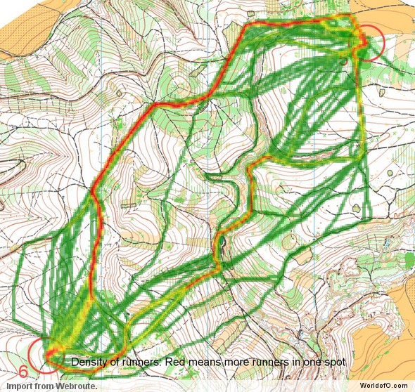
The terrain – and how to master it!
The terrain around Voss is dominated by marshlands (easily run) and grassy slopes, with a moderate degree of steepness. To get an impression about the terrain, you can take a look at the below map extract from the map of day 3 and 4. Beside the map extract, you see a picture of the terrain taken from the top of one of the mountains surrounding the map. A suggested route for this short leg is drawn in red:

As you see from the map extract, some areas are quite detalied, and reading all details in full speed is not easy as runnability is good in most of the terrain. A runner not familiar with this terrain, would probably try to avoid the marshes. In the area around Voss, you do exactly the opposite. The marshes have usually very good runnability, and in addition they are your best aid in the navigation as they are easily distinguishable (see picture to the right above where two of the marshes are marked with blue rings). Thus, you can use the marshes to make the leg easy as you see with the route drawn in red. In addition, reading contours accurately – and identifying the biggest of the small hills – is very important in this type of terrain. For example, the small hill with three cliffs to the left of the control will be a valuable aid in your navigation, as you will see if from quite a long distance.
Routechoice challenges


Again we use a leg from the new map to be used for day 3 and 4 – but an area of the map which will not be applied for the race. For this long leg, there are several alternative route choice alternatives, and it is not readily seen which is the best.
- For the leftmost (blue) you have to take some height (55 meters) in the first part of the leg – and the steep hill side at the start of the leg is probably not very good to run in (but these steep hillsides are not really bad to run in either), and from then on you have easy and fast running for the rest of the leg and a total of 60 meters climb.
- The rightmost (red) is fast and easy all the way down to the water, but then you will have to take a massive climb up to the control (65 meters). Note also that the small tracks are usually not very fast to run on compared to the marshes. Actually you will run faster down a marsh than down a small track.
- The direct route (green) is the shortest one, but it has significantly more climb than the other alternatives (90 meters climb).
- The yellow alternatives won’t help you much either regarding climb (there is actually some more climb than the green route), but you get more road and track. If you are a good road runner and poor in running uphill in the terrain, you should probably rather take the yellow than the green alternative.
- The pink route choice will take you very fast down to the road as runnability in the marshy hillside is very good and it is only downhill. It also saves you some climbing compared to the green alternative (75 meters of climbing).
In conclusion, the pink alternative will probably be the fastest if you can take the final climb. However, the blue alternative is also an interesting option.
Why choose Nordvestgaloppen 2008?
Nordvestgaloppen will give you a lot more than just the orienteering races – this is perfect holiday for the whole family!
This summer you have the possibility to combine fantastic orienteering with a spectacular nature experience. Nordvestgaloppen 2008 will take place in Voss – close to the Western Coast of Norway – about one hour by train or by car from Bergen, the Fjord capital of Norway. Voss is surrounded by high snow-capped mountains, forests, lakes and fast flowing white water rivers.
– Nordvestgaloppen will give you a lot more than just the orienteering races – this is perfect holiday for the whole family, says leader of the organizing committee Håkon Mogstad. – You will travel back home with memories of fantastic nature, interesting orienteering with overwhelming views and a big bite of the Norwegian Fjords.
It is also easy to combine Nordvestgaloppen with O-ringen. Take the bus from Salen, Sweden to Oslo, Norway, and thereafter the famous train trip from Oslo to Voss.
Orienteering + Holiday in Voss = The perfect combination!
Note! First registration deadline is March 1st – save money and register now!
Nordvestgaloppen: A lot more than just orienteering!
Voss is surrounded by high snow-capped mountains, forests, lakes and fast flowing white water rivers. It is a paradise for outdoor activities – and can offer something for all tastes: Rafting, paragliding, horse riding in the mountains, sports angling, mountain hikes, bicycle tours, kayak trips, parasailing, sightseeing by sea plane, golf – and much more.
One of the highlights in the Voss is a mountain hike to one of the mountain ridges where you can look 1000 meters directly down to the narrow Nærøyfjorden (a hike which you often can make without meeting anybody at all). Or to sit in the very same Nærøyfjorden in your Kayak looking up at the very same mountain ridge. Highly recommended – you have to experience it to know what it is like! You can take a look at the hiking possibilities at the Nordvestgaloppen homepage to see hike details and pictures for a hike going to one of the mountain ridges along Nærøyfjorden.

More a question than a comment :
as a French it is clear that we are not familiar with these terrains. However I have the feeling that the marshes in the case 1 are open land. Will it not be more clear if the background color would be yellow instead of white ?
Stefanini: The background color for the open marshes are actually light yellow, it is the color in the web production which makes it a bit difficult to see. This is the standard way of drawing open marshes. If you study map/terrain carefully, you will see that some of the marshes have white background and some blue background. I hope this clearified it?