Reminder: Price increase for registration for popular events!

Posted by Jan Kocbach, 31 May 2011@8:00

For many of the popular multiday orienteering events this summer, there is a price increase if you don’t register by either May 31st (today) or June 1st (tomorrow). For some events this is even the last chance to register at all! So if you haven’t done it yet: Choose your events for the summer – and register today!

As a service to the readers of World of O (so you don’t have to pay extra) – and to all organizers who have been kind enough to put their event into World of O Calendar along with a map sample/scenery picture, I’ve included a table with all of these events between June 11th and August 31st below.

Note that a few of the big events this summer are missing in the table below – they have not used the opportunity to get some extra PR by adding a map sample/picture in World of O Calendar. Maybe next time?

3 days of Belgium 2011
Belgium – 2011-06-11
Alpe Adria Cup 2011
Croatia – 2011-06-17
TAKAS 2011
Lithuania – 2011-06-23
Wawel Cup
Poland – 2011-06-24
WRE middle + 100CP
Estonia – 2011-06-25
Midnattsolgaloppen(Fjord-O Arctic)
Norway – 2011-06-28
Dølauka 2011
Norway – 2011-07-01
ICE-O 2011
Iceland – 2011-07-01
Kaszebe O-Cup JWOC2011Public Event
Poland – 2011-07-02
World Masters Orienteering Championships
Hungary – 2011-07-01
Czech Canada 2011
Czech Republic – 2011-07-02
BudaSprint
Hungary – 2011-07-09
6 Days of Austria
Austria – 2011-07-10
Kopaonik open 2011
Serbia – 2011-07-12
Uslar 5-Days-Orienteering
Germany – 2011-07-12
Mentor Silva Cup 2011 – Europe South-East Tour
Romania – 2011-07-13
Croatia open 2011
Croatia – 2011-07-13
HSH Vysocina Cup
Czech Republic – 2011-07-14
OO.cup/2011
Slovenia – 2011-07-22
3 days in Tuscany MTB-O
Italy – 2011-07-29
Petit Prix 2011
Czech Republic – 2011-07-29
Pannon O-Days
Hungary – 2011-07-29
Swiss O Week 2011 Flims-Laax
Switzerland – 2011-07-30
Scottish 6 Days, Oban, 2011
Great Britain – 2011-07-31
BOHEMIA ORIENTEERING 2011
Czech Republic – 2011-08-03
Argovia 3 days
Switzerland – 2011-08-12
Flanders 3-days
Belgium – 2011-08-13
O’Festival ERDF Savoie Grand Revard
France – 2011-08-14
Hungaria Cup
Hungary – 2011-08-17
Romanian Cup + Transylvania Open 2011 – WRE
Romania – 2011-08-26
O-Weekend Hamburg
Germany – 2011-08-26
Your summer orienteering plans?

My summer orienteering will be OOCup and the O’Festival ERDF Savoie Grand Revard (WOC spectator events). The reason: I think these are two of the places which I get the most challenging orienteering – important for me as I’ll be walking around in the forest. Swiss O-week, Croatia Open, Bohemia Orienteering, Kopaonik Open and Fjord-o Midnattsolgaloppen were also on my consideration list, but you can’t go everywhere. And I have to say that ICE-O 2011 on Iceland also looks very interesting, but I didn’t see it before writing this article, and now it’s too late for that…  Were do you plan to travel this summer for orienteering, and why?

O-Route Challenge: Part 1 2011

Posted by Jan Kocbach, 22 Mar 2011@22:30

The Route to Christmas series has been very popular here at World of O the last years, and there have been many requests to offer some of these “O-puzzles” throughout the year. I have therefore decided to launch a similar series of “O-puzzles” throughout the rest of the year – at irregular intervals – named “O-Route Challenge”. I do not promise a lot of posts, but if time allows and I see interesting routes I will post them here.

Starting off with Ski-O Woc

Based on previous feedback I know that quite a few of you will be disappointed with me starting off with a ski-orienteering leg, but as we have the World Ski-Orienteering Championships going these days, it feels very appropriate to start off in northern Sweden with the Ski WOC Sprint held earlier today. Not a very interesting leg – but still the most interesting today in my opinion.

The leg is as usually first provided without routes – you may take a look at it and think about how you would attack this leg (if the image is too small, you may click on it to get it larger):

Webroute

Next you can draw your own route using the ‘Webroute’ below. Think through how you would attack this leg, and draw the route you would have made. Some comments about why you would choose a certain route are always nice for the other readers.

Finally you can take a look at the GPS-data of the best skiers on each of the three alternative routes. Note that times are off the GPS, so there might be some inaccuracies at the start/end of each track.

Bonus: Pace distribution over the course

As a bonus I have assembled a pace distribution over the course. Here you can see how fast the fastest skier (of the ones with GPS) was at any point on the track.

Complete map

The complete map is available here in omaps.worldofo.com.

Route to Christmas: Day 14 2010

Posted by Jan Kocbach, 14 Dec 2010@5:00

Todays leg in Route to Christmas is another long leg from Czech Republic. This actually looks like a training course, but it still has an interesting long leg for which many runners have drawn their route. The chosen leg is number 11 in a course which consists of some long legs with routechoice options and several control-picking parts in tricky, stony areas.

The training/competition was organized at April 4th 2010. If you know more about this training/competition, please add a comment below. Please don’t forget to tip about good candidates for Route to Christmas. I have only got a few good Routegadget-choices left (thanks to some tips from you) – and then I’ll have to go over to GPSSeuranta legs from Nordic terrain the last days until Christmas.

The leg is as usually first provided without routes – you may take a look at it and think about how you would attack this leg (if the image is too small, you may click on it to get it larger):

New: A giveaway for you!?

We have been lucky enough to be able to give away a free copy of the book “O-Boka 2010″ (including shipping to wherever you live) to one of you who draws your suggested route for todays edition of ‘Route to Christmas’ in the Webroute below (remember to leave your e-mail address if you want to receive an email if drawn as a winner). “O-Boka 2010″ is a book in Norwegian language about the orienteering season 2010 including nearly 50 maps with routes (see review at OPN.no here). A nice book even if you don’t speak the language – and also a nice Christmas present.
For the record: This is a giveaway directly from the publisher to the readers of World of O as a service to the readers ; I do not receive any payment from the publisher. If you have a similar giveaway for the visitors for another day of Route to Christmas, please send an email to jan@kocbach.net with your suggestions.

Webroute

Draw your own route using the ‘Webroute’ below. Think through how you would attack this leg, and draw the route you would have made. Some comments about why you would choose a certain route are always nice for the other readers.

Then you can take a look at how the runners who have drawn their route choice solved this leg. It looks like the two main choices – going around the big hill on the left or on the right – are approximately equal, although I might favor the right variant myself. What do you think? Add a comment – or wait for the density map this evening if you don’t want to speak up…

Below you see a density map based on who has drawn their route in the Webroute. A majority of the ones drawing their chosen route have found a variant to the right of the hill to be the best option – with two different options for the last part of the leg.

Complete map in Omaps.worldofo.com

You find the complete map and Routegadget info in omaps.worldofo.com at this location.

Omaps.worldofo.com

The ‘Route to Christmas’ series at World of O was very popular the last years – and I’ve therefore decided to continue the series this Christmas as well. If you have got any good legs in RouteGadget from 2010-competitions – or old forgotten ones which are still interesting – please email me the link at Jan@Kocbach.net, and I’ll include it in Route to Christmas if it looks good. Route to Christmas will not be interesting if YOU don’t contribute.

There will be no analysis about the best routechoice for each leg – you can provide that yourself in the comments or in the Webroute. Not all legs are taken for the interesting routechoice alternatives – some are also taken because the map is interesting – or because it is not straightforward to see what to do on a certain leg. Any comments are welcome – especially if you ran the event chosen for todays leg!

Note that there may be some errors in the Routegadget data (sometimes somebody draws a route for another runner just for fun). Please add a comment below if you spot en error.

Route to Christmas: One step further?!

Posted by Jan Kocbach, 12 Dec 2010@18:00

density_webroute_232
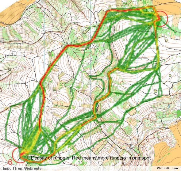
Taking the Route to Christmas series one step further, I have now set up a way to analyze your thoughts about the optimal route on the legs presented in Route to Christmas. This is done through “density maps” in which one can easily see which route the orienteering community thinks is the best route on a leg based on all the routes drawn.

Above you see a density map from the Route to Christmas of today. The density map is made by identifying how many of you choose the different routes – visualized by a deep red color for many on a route green color for few. As you can see, most of the 120 drawing their route when this diagram was made choose a variant to the right, avoiding the big valley along the direct route. Also, quite a few choose variations of the direct route.  Most of the ones choosing the direct route run straight south out of the control down the path.

For your comparison, below is the routes chosen by selected runners in the competition in question.  Looking at the direct option, none of the runners in the competition for whom routes were drawn choose to follow the path south out of the control. The reason for this is probably that the white forest is so fast that it is better to cut through the forest than to take the path.

These density maps do of course not tell anything about which route is the fastest – but it is still interesting to see what people not familiar with the terrain think about the various choices. If you have any suggestions for further improvements, please add a comment below.

I have made similar density maps for all the days in Route to Christmas so far (see below). Note some have obviously had some fun drawing strange routes some days – they can easily be spotted in the illustrations below. Also, for some days the different routes are so spread out that it is difficult to see anything at all on the map. This is the kind of legs which are excellent from a spreading perspective – as the chances for group building is a lot reduced for this kind of legs. Enjoy!

Update! The idea to these density maps are partly based on an article on O-zeugs earlier this year, showing similar density maps based on Routegadget entries)

Route to Christmas 2010 – Day 1

See all information about this day of Route to Christmas here.

Route to Christmas 2010 – Day 2

See all information about this day of Route to Christmas here.

Route to Christmas 2010 – Day 3

See all information about this day of Route to Christmas here.

Route to Christmas 2010 – Day 4

See all information about this day of Route to Christmas here.

Route to Christmas 2010 – Day 5

See all information about this day of Route to Christmas here.

Route to Christmas 2010 – Day 6

See all information about this day of Route to Christmas here.

Route to Christmas 2010 – Day 7

See all information about this day of Route to Christmas here.

Route to Christmas 2010 – Day 8

See all information about this day of Route to Christmas here.

Route to Christmas 2010 – Day 9

See all information about this day of Route to Christmas here.

Route to Christmas 2010 – Day 10

See all information about this day of Route to Christmas here.

Route to Christmas 2010 – Day 11

See all information about this day of Route to Christmas here.

Route to Christmas: Day 10 2010

Posted by Jan Kocbach, 10 Dec 2010@5:00

Todays leg in Route to Christmas is a leg from the United States with several routechoice options. The competition is the 31st West Point Orienteering Meet on May 2nd 2010, and control 2 in the blue course is chosen. This is one of those legs where you feel you have to choose between “several evils” – no choice looking perfect…

The leg is as usually first provided without routes – you may take a look at it and think about how you would attack this leg (if the image is too small, you may click on it to get it larger):

Webroute

Next you can draw your own route using the ‘Webroute’ below. Think through how you would attack this leg, and draw the route you would have made. Some comments about why you would choose a certain route are always nice for the other readers.

Then you can take a look at how the runners who have drawn their route choice solved this leg below. Ross Smith has the fastest time by running furthest to the left – avoiding some climb and green compared to the ones running more straight, but instead running on stony ground and running a longer route. Based on the information available, I can’t say if straight or left is faster. The right variants seem slower based on the runners who have drawn their route. You find all information about the event – including invitation and results here.

Bonus leg: Leg 15

Leg 15 in the same competition is a bonus leg – going in the opposite direction but except for that a very similar leg.

The leg is as usually first provided without routes – you may take a look at it and think about how you would attack this leg (if the image is too small, you may click on it to get it larger):

Bonus leg: Webroute

Next you can draw your own route using the ‘Webroute’ below. Think through how you would attack this leg, and draw the route you would have made. Some comments about why you would choose a certain route are always nice for the other readers.

Then you can take a look at how the runners who have drawn their route choice solved this leg:

Complete map in Omaps.worldofo.com

You find the complete map and Routegadget info in omaps.worldofo.com at this location.

Route to Christmas: Day 9 2010

Posted by Jan Kocbach, 09 Dec 2010@5:00

Todays leg in Route to Christmas is from Spain – in a maze-like area full of rocks, paths and green areas. The chosen leg is leg number 18 in the Men Elite course from the CEO 2010 event at April 4th 2010. This leg is not of those very long legs where you search a lot for a possible route – it is rather a short leg which included due to the interesting terrain.

The leg is as usually first provided without routes – you may take a look at it and think about how you would attack this leg (if the image is too small, you may click on it to get it larger):

Webroute

Next you can draw your own route using the ‘Webroute’ below. Think through how you would attack this leg, and draw the route you would have made. Some comments about why you would choose a certain route are always nice for the other readers.

Then you can take a look at how the runners who have drawn their route choice solved this leg. The basis for choosing your route on this type of leg is a bit different than on the longer legs which have been the topic in Route to Christmas the previous days. Here typically simplification and risk-reduction while keeping the speed at a maximum is what dictates the choice. Without having been in the terrain, it looks to me like attacking the control from below is the most secure way – following e.g. the blue route of BB.

Complete map in Omaps.worldofo.com

You find the complete map and Routegadget info in omaps.worldofo.com at this location.

Route to Christmas: Day 6 2010

Posted by Jan Kocbach, 06 Dec 2010@5:00

Todays leg in Route to Christmas is a really long leg from Pinseløpene in Kongsberg, Norway. Kongsberg is famous in the orienteering world for having many interesting terrain types within a small area – and several important competitions have been held around Kongsberg. One example is this year Military World Champs which was held in the Kongsberg area – another example is WOC 1978 which was also held in the Kongsberg area.

After many legs in Men 21, we are now up in Men 50 category (as very few Men 21 runners have drawn their routes). We are looking at leg number 8 in the H50. Thanks to Terje Mathisen for the tip about this leg.

The leg is as usually first provided without routes – you may take a look at it and think about how you would attack this leg (if the image is too small, you may click on it to get it larger):

Webroute

Next you can draw your own route using the ‘Webroute’ below. Think through how you would attack this leg, and draw the route you would have made. Some comments about why you would choose a certain route are always nice for the other readers.

Then you can take a look at how the runners who have drawn their route choice solved this leg below. The best times are run for a direct variant. Terje Mathisen’s comment about the leg (run the southern-most variant): – I think I took the optimal route choice with respect to avoiding uphill in “lyng” (high undergrowth). Please add a comment below if you ran the leg and have further information about it.

Complete map in Omaps.worldofo.com

You find the complete map and Routegadget info in omaps.worldofo.com at this location.

Omaps.worldofo.com

The ‘Route to Christmas’ series at World of O was very popular the last years – and I’ve therefore decided to continue the series this Christmas as well. If you have got any good legs in RouteGadget from 2010-competitions – or old forgotten ones which are still interesting – please email me the link at Jan@Kocbach.net, and I’ll include it in Route to Christmas if it looks good. Route to Christmas will not be interesting if YOU don’t contribute.

There will be no analysis about the best routechoice for each leg – you can provide that yourself in the comments or in the Webroute. Not all legs are taken for the interesting routechoice alternatives – some are also taken because the map is interesting – or because it is not straightforward to see what to do on a certain leg. Any comments are welcome – especially if you ran the event chosen for todays leg!

Note that there may be some errors in the Routegadget data (sometimes somebody draws a route for another runner just for fun). Please add a comment below if you spot en error.

Route to Christmas: Day 5 2010

Posted by Jan Kocbach, 05 Dec 2010@5:00

Todays leg in Route to Christmas is from Scotland: – It’s one of the toughest areas in the World. And thats on a dry day! Mix in a persistent rain and the Trossachs becomes about as tough as it gets. Marsh, rock, heather, crags, streams and hills. Lots of hills. But the courses are the same for everyone, so the toughest will win [from a report from the Senior Home Internationals in 2004]. The chosen leg is leg number 2 in the mens elite course from the “Trossachs” WRE event on March 28th 2010.

The leg is as usually first provided without routes – you may take a look at it and think about how you would attack this leg (if the image is too small, you may click on it to get it larger). You find the results from the event here. See also this training map from Øystein Kvaal Østerbø from the Trossachs map. Updated information! Note that on the race map the road was out of bounds up to the car park by the Loch (from the comments below).

Webroute

Next you can draw your own route using the ‘Webroute’ below. Think through how you would attack this leg, and draw the route you would have made. Some comments about why you would choose a certain route are always nice for the other readers.

Then you can take a look at how the runners who have drawn their route choice solved this leg. As you can see, there are not big differences in running time for the different straight-on options – but the runner going to the left along the road looses a lot of time. Of all runners drawing their routechoice, this is the only runner going all the way down to the road. Updated information! Note that the road was out of bounds up to the car park by the Loch (from the comments below).

Complete map in Omaps.worldofo.com

You find the complete map and Routegadget info in omaps.worldofo.com at this location – and can see the position of the map in the map to the right.

Omaps.worldofo.com

The ‘Route to Christmas’ series at World of O was very popular the last years – and I’ve therefore decided to continue the series this Christmas as well. If you have got any good legs in RouteGadget from 2010-competitions – or old forgotten ones which are still interesting – please email me the link at Jan@Kocbach.net, and I’ll include it in Route to Christmas if it looks good. Route to Christmas will not be interesting if YOU don’t contribute.

There will be no analysis about the best routechoice for each leg – you can provide that yourself in the comments or in the Webroute. Not all legs are taken for the interesting routechoice alternatives – some are also taken because the map is interesting – or because it is not straightforward to see what to do on a certain leg. Any comments are welcome – especially if you ran the event chosen for todays leg!

Note that there may be some errors in the Routegadget data (sometimes somebody draws a route for another runner just for fun). Please add a comment below if you spot en error.

Route to Christmas: Day 4 2010

Posted by Jan Kocbach, 04 Dec 2010@5:00

Todays leg in Route to Christmas is a long leg from sandstone terrain with deep valleys in Czech Republic – making some interesting routechoice options. The chosen leg is leg number 7 in the Men 21E course from a national race in the Novy Bor area at June 6th 2010.

The leg is as usually first provided without routes – you may take a look at it and think about how you would attack this leg (if the image is too small, you may click on it to get it larger). You may also take a look at a scanned version of the map with the complete course here (not including route choice on the leg in question). Full results with splits are available here.

Webroute

Next you can draw your own route using the ‘Webroute’ below. Think through how you would attack this leg, and draw the route you would have made. Some comments about why you would choose a certain route are always nice for the other readers.

Then you can take a look at how the runners who have drawn their route choice solved this leg. Note that the fastest runners have not drawn their route for this particular leg – Martin Janata who is best of the runners listed here finished 6th overall. Update: I just received an email from the winner of the race Jacek Morawski, who had not drawn his route in Routegadget. He run the leg in 11:08 by following a route similar to Vojtich Kral in the first half of the leg, but then choosing a more southern route for the last part of the leg (not shown below).

See also maps from this race and nearby races in omaps.worldofo.com. If you participated in the race and know more about the route in question, please add a comment below!

Complete map in Omaps.worldofo.com

You find the complete map and Routegadget info in omaps.worldofo.com at this location.

Omaps.worldofo.com

The ‘Route to Christmas’ series at World of O was very popular the last years – and I’ve therefore decided to continue the series this Christmas as well. If you have got any good legs in RouteGadget from 2010-competitions – or old forgotten ones which are still interesting – please email me the link at Jan@Kocbach.net, and I’ll include it in Route to Christmas if it looks good. Route to Christmas will not be interesting if YOU don’t contribute.

Note that there may be some errors in the Routegadget data (sometimes somebody draws a route for another runner just for fun). Please add a comment below if you spot en error.

Route to Christmas: Day 3 2010

Posted by Jan Kocbach, 03 Dec 2010@5:00

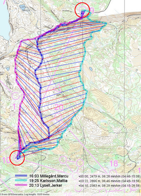
Todays leg in Route to Christmas is from a really long leg in Norway – featuring Olav Lundanes and Anders Nordberg among others. The chosen leg is leg number 9 in course from the Norwegian qualification races for WOC in Trondheim organized at July 4th in Verdal, Norway.

Note that there was no GPS tracking for the Norwegian runners – but for the Swedish runners who had the same leg there was GPS tracking. Some details from the GPS analysis of the Swedish runners is included below.

The leg is as usually first provided without routes – you may take a look at it and think about how you would attack this leg (if the image is too small, you may click on it to get it larger). Note that the leg goes from north (control number 8) to south (control number 9).

Webroute

Next you can draw your own route using the ‘Webroute’ below. Think through how you would attack this leg, and draw the route you would have made. Some comments about why you would choose a certain route are always nice for the other readers.

Then you can take a look at how the runners who have drawn their route choice solved this leg:

GPS data: Swedish test races

Sweden had their WOC selection races in the same location with very similar courses. As Sweden had GPS-Tracking for many of their runners via GPSSeuranta, it is interesting to take a look at some of their routes on this particular leg. Below I have chosen the three Swedish runners who are fastest on each of three alternative routechoices (note that split times are approximate). As you can see, Marcus Millegård is fastest with a route similar to the route of Olav Lundanes above (not shown here are routes of Erik Andersson and David Andersson who had similar routes and times of around 16:30 and 16:50). Comparing the position of Millegård along the leg with the positions of Matthias Karlsson and Jerker Lysell, you see that both Lysell and Karlsson loose time on the climb. Also, it seems that the runnability along Millegård’s route at the middle of the leg is better than for Lysell’s route.

verdal_swe_1_s

Complete map in Omaps.worldofo.com

You find the complete map and Routegadget info in omaps.worldofo.com at this location.

Omaps.worldofo.com

The ‘Route to Christmas’ series at World of O was very popular last years – and I’ve therefore decided to continue the series this Christmas as well. If you have got any good legs in RouteGadget from 2010-competitions – or old forgotten ones which are still interesting – please email me the link at Jan@Kocbach.net, and I’ll include it in Route to Christmas if it looks good. Route to Christmas will not be interesting if YOU don’t contribute.

There will be no analysis about the best routechoice for each leg – you can provide that yourself in the comments or in the Webroute. Not all legs are taken for the interesting routechoice alternatives – some are also taken because the map is interesting – or because it is not straightforward to see what to do on a certain leg. Any comments are welcome – especially if you ran the event chosen for todays leg!

Note that there may be some errors in the Routegadget data (sometimes somebody draws a route for another runner just for fun). Please add a comment below if you spot en error.

Next Page »