 World of O News
Today Route to Christmas travels to Tasmania for the 2015 World Cup terrain. We do however do something out of the ordinary in Route to Christmas today: Instead of using an actual course from 2014 as is the usual requirement, we have made a fictitious leg in the terrain where the World Cup race is to be organized early in 2015.
The disadvantage by using a leg like this is of course that we don’t have any actual data to compare with. The nice part is that all of you can take part in the speculations and preparations the World Elite is part of this Christmas – preparing for a race in this very terrain. I have no knowledge of how the teams prepare for this specific event as I have not been part of any team preparations, but from earlier World Cup and WOC races I know that the athletes and coaches typically do what we do in Route to Christmas today: Find an interesting leg, analyze it as much as possible theoretically, talk to people who have been in similar terrain (any comments from Tasmanian’s out there – please add them here?) – and identify the best solution.
The leg is as usually first provided without routes – you may take a look at it and think about how you would attack this leg (if the image is too small, you may click on it to get it larger). I actually know nothing about the terrain, but my speculation would be that the stony area to the left is not the best runnable, and probably you can run a bit extra to avoid the marshes. Good luck with your choice!
![]()
Location
You find other maps from the area in omaps.worldofo.com here. See also latest additions in 3DRerun from this area in order to learn more about this terrain type.
Webroute
Next you can draw your own route using the ‘Webroute’ below. Think through how you would attack this leg, and draw the route you would have made. Some comments about why you would choose a certain route are always nice for the other readers.
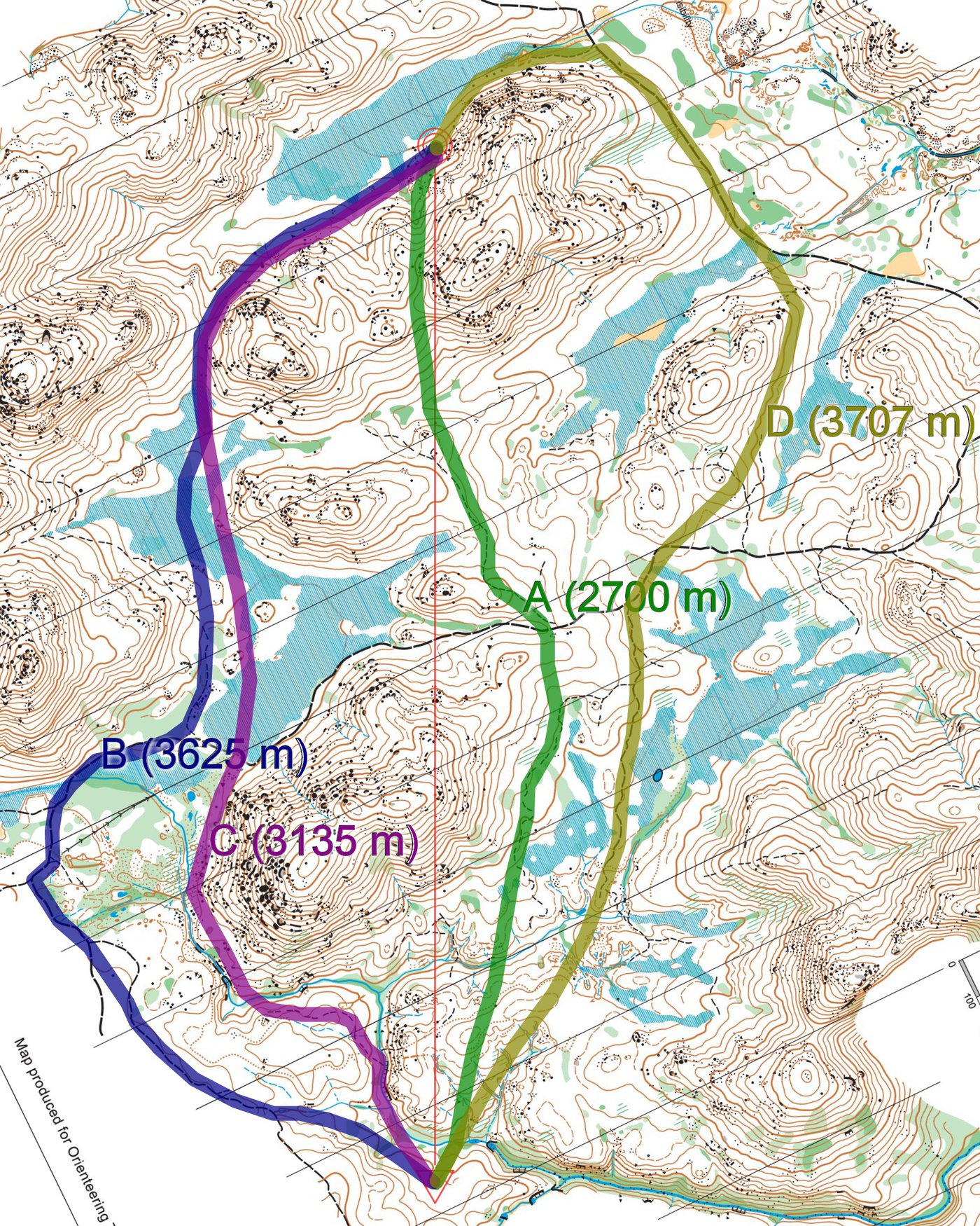
Then you can take a look at four different alternatives I have drawn (of course, the crowdsourced density map below might be a better guideline).
My preferred route would be the most direct A, which is nearly a kilometer shorter than going either left or right. You do take some extra height and do have less running on paths, but at least you are mostly in white forest. I hope somebody can add a comment about how the white forest is here – maybe the white is so slow that you need to go around (I would probably learn about this at the latest when arriving in Tasmania)? In that case, D would be my second choice. You have quite a lot of path running, you save height and the control is easy from behind.
With no GPS-data, today’s analysis is only speculations – but hey, that’s how the World’s best do it, so we can do just the same for once ….
Density map
See below for a density map of some of the ones who have drawn their routes so far.

Additional information
You find the complete map in omaps.worldofo.com at this location.
Route to Christmas series
The Route to Christmas series at World of O has been very popular the last years – and I have therefore decided to continue the series this Christmas as well. If you have got any good legs in RouteGadget, GPSSeuranta or 3DRerun from 2014-competitions – or old forgotten ones which are still interesting – please email me the link at Jan@Kocbach.net, and I’ll include it in Route to Christmas if it looks good. Route to Christmas will not be interesting if YOU don’t contribute.
Not all legs are taken for the interesting routechoice alternatives – some are also taken because the map is interesting – or because it is not straightforward to see what to do on a certain leg. Any comments are welcome – especially if you ran the event chosen for todays leg!
Note that there may be some errors in the Routegadget data (sometimes somebody draws a route for another runner just for fun). Please add a comment below if you spot en error.


I’m pretty sure the control would be placed at least a couple of contours higher, making it less tempting to just aim for the marsh and take it from below.
I have run here a few times in the past. The white is quite OK but leaf litter often means you can struggle to get a firm footing on some of the steep slopes and fallen timber means it is tougher running than many terrains on the big island to the north. Oh and I’d avoid the marshes as the snakes like those when its warm :) but more so that they are tough to run across even when dry.