World of O News

Analysis of GPS tracking data from races outside Europe is still a novelty in the orienteering world. With the exciting and picturesque native forest of the Oceania 2011 Orienteering Championships – and several longer legs with different route choice options – this was really an interesting task to set out on.
This is by no means a complete analysis – but rather some illustrations and thoughts giving you some insight into orienteering challenges on the other side of the world compared to where most of the readers of World of O are situated.
Thanks a lot to Chris Terkelsen of TracTrac for providing me with the raw tracking data for the analysis.
Useful links:
Long distance: Hilly, hilly

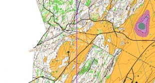
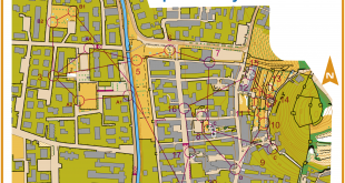
On Saturday October 1st, the Oceania Long distance Championships was staged in Wangaratta. The terrain is generally open eucalypt forest with areas of slow running, undulating to steep in sections, with complex granite rock feature. It is described as technically challenging terrain in some of Victoria’s most picturesque native forest. You see a map extract of the first four controls in the men’s course above – and a picture of the terrain on top of this page and another one below (all photos courtesy of the Oceania 2011 webpage). This surely is not like your usual European terrain.

As usually, it is chosen to divide the analysis into two parts – the single-leg analysis of some of the selected longer legs, and the so-called autO-analysis where top runners are compared meter by meter to see where time is lost/gained.
M21E – leg 4-5
The first interesting leg in the mens category from a route choice perspective is the leg from control 4 to 5. The leg is first provided without routes in order for you to be able to study it properly.

Then we put of the routes of the best runners with GPS-data – colored by leg time (green = fast). Note that these times are from the GPS and thus are not accurate to the second. Below you find a table with the split times from the official timing system. It is interesting to note that most runners choose to run around to the left – although this is quite a steep, stony hillside. Without terrain knowledge, I would probably have opted for a more direct variant. Looking at the split times, the fastest times are run around to the left – but the difference between the fastest around (10:16, Rob Preston/Simon Uppill) and direct (10:46, David Shepherd) is quite small – only 30 seconds. Thus even if it looks like left is faster, the difference is probably not too big based on the available data.


M21E – leg 10-11
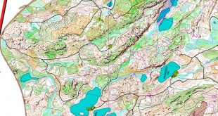
Leg 10 to 11 is the most interesting of the day. A long leg with a lot of route choice options. Should you take the big hill in the stony, slow terrain – go around to the right using the paths or to the left in less stony areas but without paths?

Below several different illustrations are used for the leg. Looking at the different options taken below with coloring according to leg time, the first that strikes you is that the left option where you use the path in the first part of the leg and then continue direct must be the best option. However, when looking more into the details, you see that for error-free running, there is actually not much difference between the left, direct and right options. Looking at the dot plots below, David Shepherd (direct) seems to loose his time in the last part of the leg due to insecurity and mistake. Rob Walter (long right on the path) also looses most of the time the last part of the leg as it seems. Thus as very often seen on this level of orienteering, the main key is to choose a secure route and good attackpoints.


AutO-analysis: Rob Preston versus David Shepherd
Comparing the winner Rob Preston with second placed David Shepherd step by step (see autOanalysis figure below – click for large sized illustration), we see that Shepherd generally looses time on the longer legs by taking other routechoices compared to Preston – Shepherd often choosing direct routes. In most cases were the two took the same choice, Shepherd is actually faster.
Generally, however, it seems like you don’t loose a lot of time by choosing the direct route in this kind of terrain – the important thing is to choose good attackpoints into the controls – insecurity in the control region seems to be one of the main time losses by the runners here.

Comparing Preston with Grant Bluett (4th place), we see that they have mostly followed the same route all the way along the course. Bluett looses a bit of time all the way – the only major time loss being on his route choice to number 16 where he runs around the hill instead of taking the climb.

Women’s course
The women’s course also had some interesting legs. Below an illustration for leg 6-7 is given. As you see, the runners who were tempted to take the road lost time – it is too far to go around there. The direct route is the fastest here. Difficult to see on this illustration is that Vanessa Round actually looses a minute – and the victory – on this leg. See the autOanalysis illustration below for more details.

Below you see an autOanalysis of the two best women – Jo Allison and Vanessa Round. Although the final difference between them was only around half a minute, they both lost significant amounts of time. Whereas Allison has a very good start – Round is a lot faster in the final part of the course, winning nearly every single section. The long legs (6-7 and 10-11) are the biggest time losses for Round – a total of more than two minutes for these two together.

Middle distance: Gold mining terrain
The middle distance terrain on Sunday was a very different one from Saturday’s long distance. The terrain was “a heavily sluiced gold mining with a network of minor tracks” according to the preview video embedded below.
– The mildly undulating area is generally slow run but is very variable across the map. The unrelenting nature of the terrain is such that competitors will be greatly challenged to manage their speed and navigation to ensure clean passage through their course. The area is more complex than any existing gold mining area known to me, the description continues.
For the middle distance two autOanalysis figures are set up without further analysis.