 World of O News
[Updated with statement from Thierry Gueorgiou] The second last control in the WOC Middle was decisive for the medals in both the men’s and the women’s class. In the women’s class Emma Johansson lost a certain gold medal due to a mistake at this control. In the men’s class Thierry Gueorgiou lost a certain medal here – and maybe, maybe a gold medal.
A reminder from the WOC middle analysis article about the incident: “Here Gueorgiou went into the green through a hole in the fence, and searched for 49 seconds before finding the control. In the end Thierry Gueorgiou was 46 seconds from the Gold medal. This was the same mistake that cost Emma Johansson the victory in the women’s class.”
Update 11/8/2015: Thierry Gueorgiou has written a comment about the control on his blog: “In my opinion, the map around the penultimate control was not up to the quality which is required at a WOC. I, of course, went there after my race to check the area and was not pleased with what I saw. Well, the fact is that it is not the first time it happens at our major championship, and we can´t even all agree on what is a good enough map. It is also worth mentioning that the map has always been the same for everyone and it is an important skill to manage to keep the risk as low as possible whatever the circumstances.”
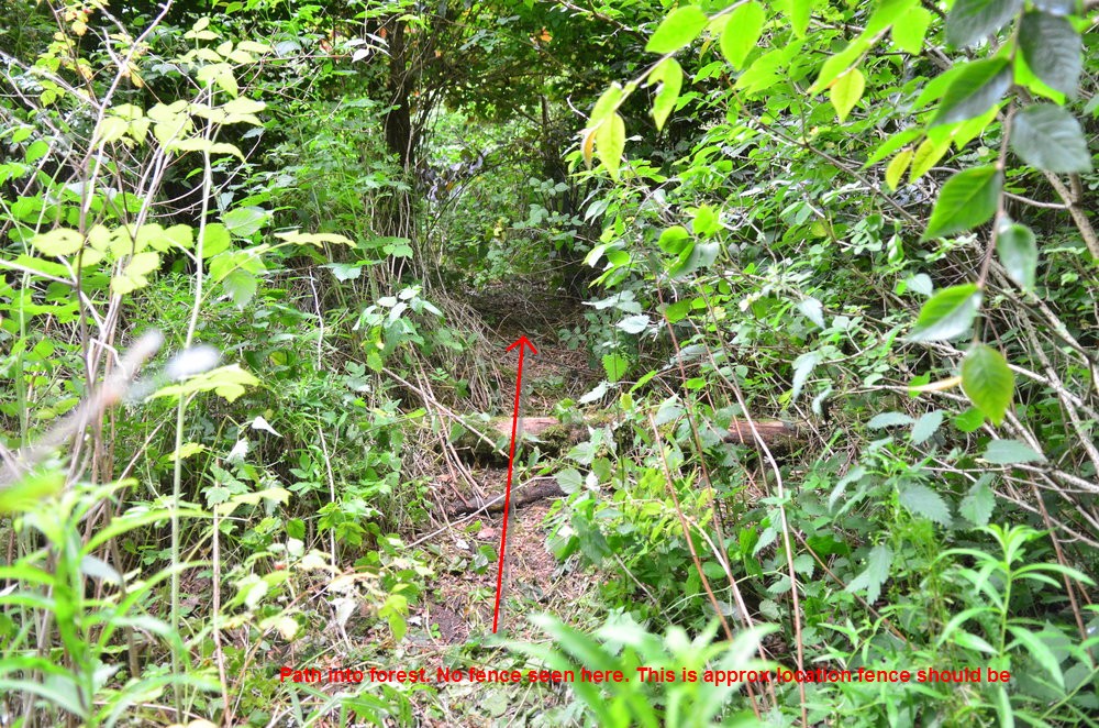
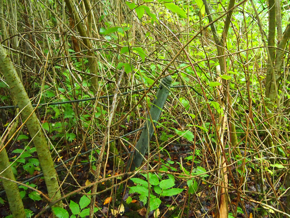
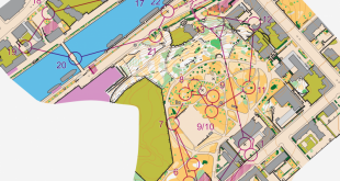
Above you see a picture from a few meters from where the path leaves the road, i.e. just before the red and blue lines at the map sample below. The red line is the line many runners have followed, including, probably, Thierry Gueorgiou and Emma Johansson. There is a very marked path from runners there – must have been many, many runners taking this way.
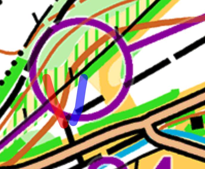
Here is a video showing three different routes to the control; first along the red line, and then just fighting to get out again (based on the GPS-tracking this could be similar to what Gueorgiou was doing; Johansson was probably even further into the green). The second does also start along the red line, and then turns right just ahead of where the fence is drawn (there was no fence to be found there, though). The third around the yellow to the right and to the control from behind.
More pictures
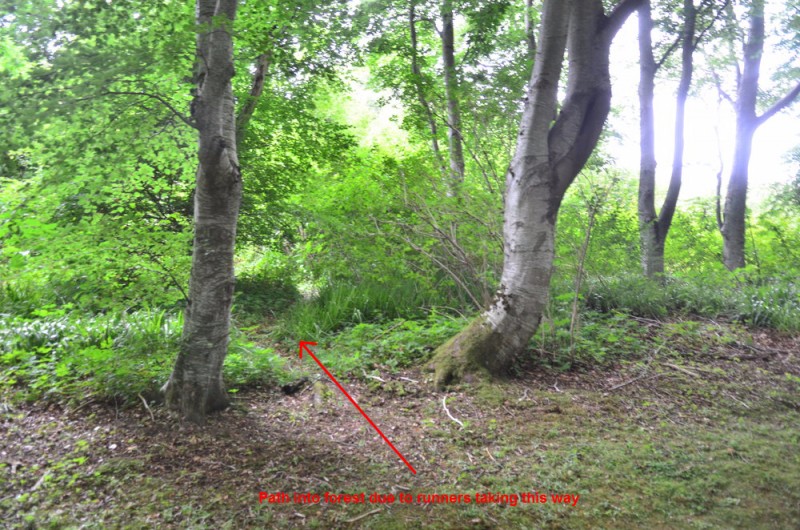
This is where the wrong path goes; compare with the first image with the two trees clearly visible.
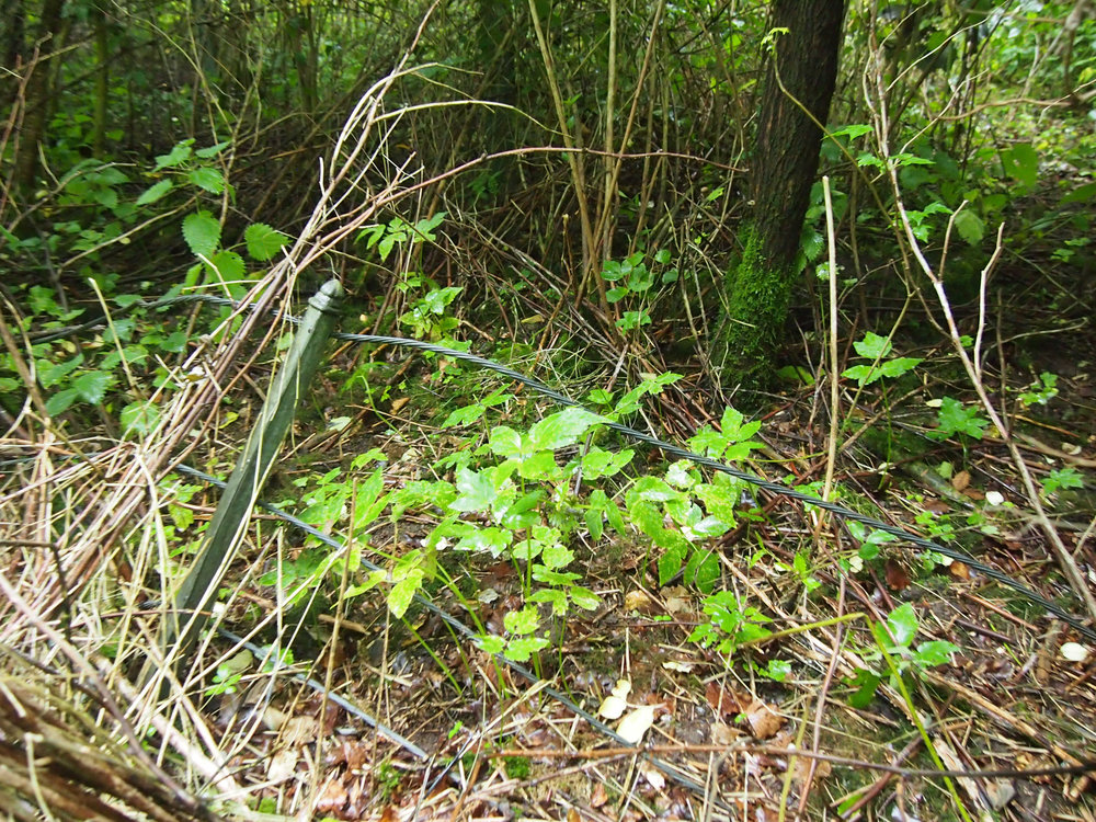
This is where the wrong path continues into the green and crosses the non-visible fence.
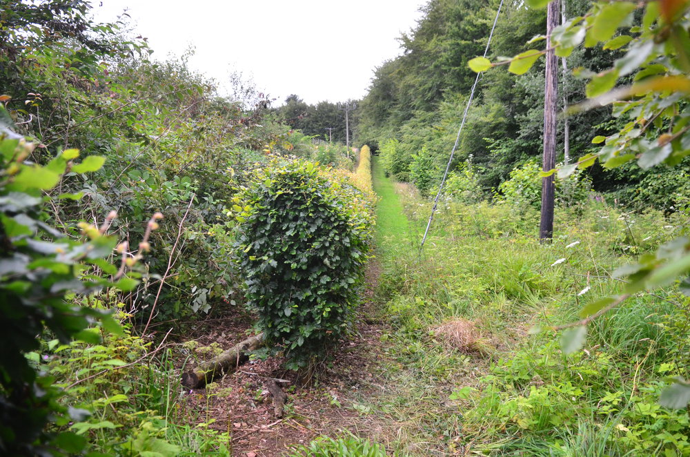
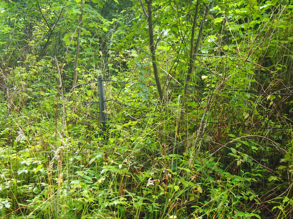
And finally the control location, the hedge.
Conclusion
The map is definitely not perfect in this area. The original article stated “through a hole in the fence” – I did however not see a fence at all there. Also, the vegetation is generally denser than one would expect from the map in this area. If the map would have given a correct representation of the terrain, i.e. if there would have been a fence here, it would not have been possible to do the big mistake Gueorgiou and Johansson made. One would have been caught by the fence, turned right, and found the control with maximum a few seconds time loss.
However, it is clear that Gueorgiou and Johansson did a mistake here – they clearly ran in the wrong direction after leaving the path. This should however rather have been punished with 2-5 seconds time loss rather than 45-90 seconds time loss, if one looks at the map.
PS! In some ways this is similar to the map problems which cost Gueorgiou a middle gold medal in Denmark in 2006 (mistake due to not 100% accurate map) and a relay gold medal in Hungary in 2009 (control difficult to find based on the map; yes, Gueorgiou would have been ahead of the Swedish team at the crucial moment without this mistake). Gueorgiou’s technique is “on the edge” – and that is mostly in a good way. If the map is inaccurate, there may be trouble…
Update 6/9/2015: E-mail and pictures from the Assistant Event Director
As Assistant Event Director I had quite a lot to do with both Graeme as planner and the IOF. I had to drop some things off at Darnaway yesterday and thought I would look at the controversial second last control. I have attached three photos – where Thierry crossed I moved the vegetation and the fence wire is clearly visible above ground level. Move NE or SW from this point and the fence is much more obvious. I am not a mapper but I would say this is a fence rather than a ruined fence. The area is probably greener than the map indicates but with the wet and warm weather there was a lot of late season growth. Johansson and Gueorgiou made a pretty basic mistake that most competent club orienteers would have soon corrected. As soon as they dived into the unpleasant green area they should have realised no planner would put a control in an area like this and they would have run back out again losing maybe 5-10 seconds.


Strange that the best runners get punished most when map is not 100%.
Good that I finally could see what I expected to see! Thanks for all pictures!
Please. I agree that a drawing fence that is not there or hardly visible is a mistake of a mapper. But come on, it is clearly very big mistake of the runners. And I would say mistake of the beginners. I know, even the champs could do such mistake.
If you have a 90degree turn of the path you just can’t run straight ahead. I suppose that it was just a miliseconds of deconcentration adding tiredness.
Please be honest. From the map AND from the video it looks like controls for beginners class. You are approaching to the 90degree turn and you could already see the clearence on the left. If you see clearance (yellow) on the right – so you have the control.
It is still a big question for me what have caused such big mistake of such high elite runners.
in the end i meant:
You are approaching to the 90 degree turn and you could already see the clearance on the right – of course.
agreed, in principle. but there are two shades of yellow, indicating a fuzzy border, which may or may not be clearly visible from the attack point where the planned route leaves the path. and, at top speed, i do not process all the information – i first select that which is relevant and reliable.
here: “off the path, a little to the right, turn right before the fence and follow it to the beginning of the hedge.”
if the route plan had read: “”off the path at 45 degrees, see beginning of hedge at a distance of 30 m (?) at the end of the open forest.” all would have been well.
another point: beginners making this mistake wouldn’t be fully back on track in 40 seconds.
@jan: are you suggesting the third route presented on the vid is the best?
and: thanks again for the material; this is truly superb stuff.
excellent, thanks a lot.
top-speed orienteering appears to be a lot about reducing redundancies. there’s no need to consider vegetation nor to be overly precise about angles if the fence is there as a clear guiding line to the control. now if the fence is missing, the safety net that would be provided by all the other pieces of information cannot be relied upon – it was never mentally created.
the challenge that remains is which data to filter out. big G and johansson were unlucky with their choice of filter.
PS, after viewing the vid: if the green fence posts belong the the fence in question and not to the one further back/north, the symbol chosen for the fence apparently ought to have been the discontinuous one.
Not sure to see clearly from the pictures and video, but it also seems that the vegetation isn’t mapped the right way, the yellow and green stripes area don’t seem so open, green area would be better?
Anyway, quite a pity that a “a tricky beginner control” decided a WOC race.
If there is no fence in terrain, is it OK to set a control there? When I am a coursesetter or EA for our small national events it’s a no go. No matter if it’s beginner’s or Elite course.
It’s too obvious object missing in circle to just ignore it.
There might be a fence, but I could not see it, but I did not search very hard for it – just generally looked for it in this area – it was very green and unpleasant there. I should have crossed it a few times, so at least it was very broken. The thing you see in the video which may look like an old fence is not a fence, but plastic around trees to protect them (probably from the time before this area got green).
Hi Jan – sorry I didn’t meet you at WOC! I too went for a look at the control site. The remains of the fence are visible, just. The posts are grey metal, approx 1 metre high. The fence is/was wire rope which has dropped to the ground so that it’s not visible unless you trip over it.
A few people have blamed the competitors but that’s not fair. It’s reasonable to expect a mapped fence to be a physical barrier, and reasonable to use it as a navigational aid.
I agree with the comment that this control was not mapped/controlled properly because it was deemed to be easy. Hopefully lessons will be learned!
Gregor saids it all.
It’s all about top speed and filter at crucial last controls of the race.
The fence approach was supposed to be one of the safest in my opinion.
Replace the fence with a road in your mind, and see the problem…
I’m actualy surprised such a big map issue hasn’t been noticed before, considering it is a WOC race (and the fence an attack point…)
Thanks a lot for sharing this tricky point ! And thanks for the rest of the good job you’re doing here ;)
What about the power line poles ?
Is it possible they mixed up the symbol and there was no fence but a power line. Jan you have been there. Is that possible.
You should never trust fence is unbroken. It can get broken by early starters stepping on it. Quite risky to count on something like that. It may have been just a wire gut well visible one at first, and early starters stepping on it so it was already mostly on ground for late starters.
But that rough open with green undergrowth stripes. Yellow means vegetation is not higher than 1m. Green stripes means vegetation is well lower than 2m (should be good visibility, right?). To me it looks its more like over 3m high bush. That’s green. Athletes may have expected to hit something open on both left and right (and not just fence) and never finding any open at left, because there was no such open at all.
This photo. That quite high jungle left of fence is mapped as rough open with undergrowth stripes!? So if you are waiting for rough open and possibly fence, fence is down and you end up hitting only this, well, can you can get confused…
http://news.worldofo.com/wp-content/uploads/2015/08/DSC_0585_s.jpg
A perfect example why Orienteering is so interesting and unsuitable for Olympic Games sport.
I don’t think this is fair. It has introduced an element of luck into the race. You would rightly expect to see a fence and turn right using Georgiou’s approach. I personally would feel cheated and I think the race was compromised by this map error. That is a bit careless by the controller.
Well, on the last photo – from the left side of CP – there is a clearly green area – nothing about yellow and green stripes (should be open). On the map it looks very-very simple control. I would expect it to be visible from road bend. But even if not – the black line of the fence should 100% lead us to the CP… Seems to be a mapper/course setter error as probably such ‘easy’ places were not checked and all effort was given to the forest part.
I also visited the area just after the last finishers. The fence is there, but should probably now be shown as ruined/discontinuous, I’m not sure what state it was in at the start of the competition. The vegetation could be micro-mapped to better show what is on the ground, but this is a 1:10,000 map so some generalisation is required. Going in the wrong direction from the path corner is a mistake.
After having seen these pictures and the video I feel a lot more sympathy for the mapper. To map this kind of area with ISOM is just masochism. You will never get a map that is both legible and accurate enough to place controls there. A taped route would have been better and more fair.
So, the top 6 map problems I could see on the pictures and video (I call them problems not errors because there is no easy fix to all of them and with a different control placement they wouldn’t have been problems at all):
1. The yellow with green stripes (403 + 409) has no visibility at all and should have been marked with green. This is obvious now, but was the fieldwork for the map made in the wrong season or wrong year..? And why did nobody notice this when the vegetation started to grow?
2. The fence is ruined/broken/impossible to find.
3. The footpath (506) is not “distinct on the ground” like ISOM says it should be. The difficult question is how to map a track like this? Vehicle track (505)? Narrow ride (509, but usage like this would be quite strange outside of Scandinavia)? Yellow strip? White forest?
4. The bend in the footpath is not as distinct as it is mapped.
5. The distance from the bend in the footpath to where the “green” starts is a lot less than on the map. 8-10 metres on the map, 2-3 metres in reality. There also seems to be a lot more “white forest” on the right side of the footpath than on the left side, which is confusing when the map gives the opposite impression.
6. In general there seems to be something weird with angles and distances in the area. If the last route Jan took in the video really is the fastest, there must be some problems. Looking at the map, going to the bend and then straight through white forest to the control is clearly fastest..?
Obviously map in this plase has been draw usind wrong symbols – 403 + 409 are justt uncorrect. I know that mapping such place is generally not easy – many elements, lot of runnability changes, paths with various visibility and history. and the fence (not-fence).
But most of all I consider this as course setter error. I’m pretty sure course setter put this control just to avoid a long, 500 meters run on hard road from control 23 to control 25. I’m convniced he did not imagine that this control would make any technical issues to runners. Basically it should be “very easy” control point. When you expect a risk you control everything many times, but if think it’s obvious – you simply don’t.
I was leading a basic course for beginners in good old MS-DOS days. I have a plan to make an introduction within 4 hours. Usually it worked. But once I had somebody who asked “what do you mean this directory is directory by default?”. When one person asks all the others started to ask and that was the day I learned that “obvious” is never as obvious as you think. Took 3 hours to explain what really “by default” means and I’m not sure everybody understood.
Be afraid of “obvious” places you runners and course setters!
So the map was over-generalised?
The generalisation level is probably okay, but ISOM is just not very well suited for park areas. If you look at the map all the green and yellow seem to be a bit “fuzzy” (no vegetation boundaries) and you woudn’t expect it to be easy to use as navigational aids. But for the control to be fair, the footpath and fence must be distinct because that’s what you have to rely on if you make a small mistake.
I am the course-setter. I very much appreciate the detailed analysis.
The video analysis is a bit disingenuous. The video camera is held very low, well below eye level, which makes the visibility appear much lower than it is (403/409, followed by green 406 is definitely correct here). The fastest route is the blue line, cutting through the woods from the point where the control flag is first visible. It was taken by most runners, resulting in a clear track.
There is a continuous fence. When I looked at the end of the day, the top wire was broken on the path shown. There is a continuous lower wire about 30cm off the ground, which you could step over (or trip over). The “409 Undergrowth: difficult to run, 20-60% normal speed” extends in front of the fence, so I don’t think you should expect to see the fence.
The 506 footpath was mapped as a yellow strip until about three months ago: certainly a valid option. A late map revision was done, and I think but 506 is OK too, and by that stage there was so much other ridiculous nonsense coming from the IOF there were many many more important things to deal with. I spent a lot of time in that area: in my original draft I intended to use the hedge end to the SW, approached between hedge and fence, and clear away the undergrowth. This got vetoed by the controller.
However, I am comfortable with this leg. The map shows clearly that there is no need to go into the “409 Undergrowth: difficult to run”. Anyone who went where the video went, thinking they were cutting through white forest cannot blame the map. Anyone who went straight on from the gate instead of turning right cannot blame the map. Late starters normally have a big advantage from elephant tracks through the undergrowth, they cannot complain if sometimes they are misleading.
I expected that this leg could make a difference, and wrote many emails explaining why because nobody believed me. I had analyzed many elite races before WOC, and concluded that at the top level nothing in Darnaway is really difficult. The challenge I set was about continually changing the navigation style. In particular, I noticed that mistakes often come at the end of very fast sections. I also expected mistakes to come right at the end finding the gate into the field, where you have to be at the right level on the slope, not too high (Mari Fasting) or low (Ole Bostrom).
I came into the planning process believing that at elite level there is no such thing as a difficult or easy control; what is difficult is to assess how fast you can safely approach it. I come out of it with the same view.
@Graeme: Thanks a lot for your comment and clarification. To point out that first: My point of view is that the athletes who lost significant time on this control did it because they made a serious direction mistake into the control (completely wrong angle), and can’t blame the map for that. The map not being perfect (I think the fence definitely should not have been drawn this way on the map after being there; I would also have drawn the green differently) was part of the reason for the time losses becoming this large, but the map is never perfect. But my understanding of the area is not the same as yours (but I have only been there once for 7-8 minutes) – as I explain below.
> There is a continuous fence. When I looked at the end of the day, the
> top wire was broken on the path shown.
I really looked for the fence without seeing it. I did not search hard (as I was a bit in a hurry as I was fighting the Internet-problem in the arena), but I looked for it, also at the ground. Both at the place were I ran into the green and at the place were I ran out of it again. So it really can not be that clear. There might have been a single wire all the way down at the ground, but definitely not 30 cm above the ground.
> The “409 Undergrowth: difficult to run, 20-60% normal speed” extends in front of the fence,
> so I don’t think you should expect to see the fence.
From the map, I would expect to see a fence, even if there is undergrowth there? Or would you really not expect to see any fence the way the map is drawn?
> The video camera is held very low, well below eye level, which makes the visibility appear
> much lower than it is
The reason the camera is held low is that the only way I managed to move inside that bushy area was to crawl close to the ground / run with my head down. At least that is how I experienced the area, but I might have been unlucky with which way I chose through it.
> The fastest route is the blue line, cutting through the woods from the point where the control
> flag is first visible. It was taken by most runners, resulting in a clear track.
For a late starter, yes maybe. For an early starter, I think going around would be faster. It didn’t feel like white forest through there, though.
Jan,
Thanks for the quick reply.
From the map – would I expect to see a fence behind a mapped ~5m strip of 409 undergrowth? Yes, I would. Would I rely on seeing the fence? No, especially not if the undergrowth was obviously as nasty as it was.
Do I think anyone’s plan for finding the control was “plough through the grot until I hit the fence, then turn right and follow the fence through the grot”? No. Similarly, if the fence had been mapped as ruined fence, would it have made a difference? I don’t think so: at that stage someone who can’t tell right from straight or fight from white isn’t going to notice a small gap in the fence symbol.
“It didn’t feel like white forest through there”. There are a couple of low branches and some quite long grass, but its more runnable than plenty of the map. Interestingly, my first reaction was also that it didn’t feel like white forest. I think the reason is that that section feels like parkland, so you expect the white to be super-runnable like on a sprint map.
It’s not over until it’s over, and I still have no sympathy for the runners, though I will confess to cheering for a Thierry comeback in the long.
(I’d also like to mention that the competitor’s maps had lines and circles properly broken for clarity, the GPS tracking version loses this)
I don’t think that runners who were on a bearing heading a little bit left of the control were making a mistake.
If you believe that you can trust to see fences mapped (which I do, but not Jagge), it is actually quite smart to aim a little bit to the left of the control if you want to be sure not to make a big mistake. Because if you do so, you are sure that when you hit the fence you turn right and very soon get to the control. Even if you are going a few degrees left or right of your bearing. This way you make the control “longer” and easier. This is an especially good tactic if the vegetation is dense and you don’t expect the control to be very visible.
If you instead aim straight to the control, and make a few degrees bearing error, and then hit the fence without seeing the control. How do you then know if you should turn left or right??
I thought this kind of tactics to make the control “longer” (which maybe Thierry G and Emma J were using?) was common sense in top-level orienteering?
The fence should be a barrier and Gueorgiou & Co looked for a stop line and a line conductive to the control post. If there are several holes, had used the symbol 523. If there is only a hole had used the symbol 522 + 525 . Not even close we can not speak of generalization, but erroneous use of a symbol. The symbol used is completely wrong and caused the mistake. Thierry retained in the area: a: point of attack, and b, stop line and conductive line.As line stop and conductive that the fence was not seen him …
Everyone can make mistakes. But if this mistake creates injustice, should straighten it.
It would have been correct the results to be canceled.
There is no such thing as 100% accurate and perfect map. Every map is skewed and not perfect one way or an other. No matter how it is mapped or is it drawn according to the ISOM or not. But ISOM defines the way our maps are supposed to be imperfect, so athlete knows what type of imperfectness to expect. It does it with rules like legibility expectation, minimum dimensions, fixed set of symbols, only one form line and so on. And athletes should know all that and prepare for those types of inaccuracies and imperfectness, and not count on solely on one thing that may be or may not be 100% accurate. And course setter should make sure the map is not misleading (it does not need to be perfect) to ensure race is fair.
So, was the map too misleading? If so, should we have fence repair teams in forest waiting and watching, ready to repair fences every time one get broken during the race? Or should we allow mappers to use own custom symbols for different types of fences, so we would have symbol for “not well visible fence that may get broken”. Or should we expect best navigators know how to execute legs like and find controls like this (end of a big, half kilometer long distinct hedge coming slightly from right) both fast and safe way – no matter is a single fence wire (at left side) stepped on by someone or not? Seriously?
This discussion about map quality has gone too far. In the last number of years map quality has been discussed endlessly and both athletes and coaches as my self “demand” 100% perfect maps. Sorry guys – it will never happen. An Orienteering map is and will always be the mappers interpretation of the terrain and how to simplify it. The task of any orienteer is to understand the mappers interpretation. This will always leave situations where some might have mapped differently, and some might even think it is a wrong map. But there is no wrong map, it is an interpretation and such will always have situations where the map is hard to understand for some and easy to others.
I’m not writing this to ask people to accept low map quality. Of cause it has to be as good as possible, what I’m saying is things need perspective. As many others I have also been to the area of discussion, though only for a minute or two – 10-15 times longer than any competitor was supposed to use for navigating toward the particular control. But the time spend there was also sufficient to establish this controls was nowhere near unsuitable for a WOC race. Yes, one could have chosen to map the fence as a fallen fence, and yes the power lines could have been added. But those things are not important for either attacking the control nor relocating.
Looking at this discussion it seems there is more a kind of need to find an excuse for missing the particular control. Being so easy I can understand the urge to blame the map, but in my opinion the course setter managed to do exactly what his goal was – to punish competitors who were either tired, stressed or who lowered their level of concentration(due to the control looking easy). The yellow area with undergrowth didn’t exactly invite one for a pleasant run, and anyone going there asked for trouble.
Back to the discussion on whether the map can or cannot be perfect. As said the map is an interpretation and therefor cannot be perfect in anyone’s mind. That is a fact. The only path too follow to achieve “perfect” maps is to computer generate maps from LIDAR data. The will be the absolute “truth”, but also this can be discussed. Was it the correct settings or should the algorithm calculate the map in a different way. Therefor I’m convinced this will not lead to less discussion on mapping quality, on the contrary it will lead to even more. LIDAR and computer algorithms are simply not good enough to be an acceptable solution.
To summarize things. Graham Ackland and his team did a great job. The map was not bad in the area in question, but some might have mapped it differently. And the control was suitable for a WOC race.
Thank you Scotland for a fantastic week. And to any one else, in less than two months there is a new chance to master the middle distance. May the games begin.
This is not about map quality in general or 100% perfect maps. It´s just about a mapped fence that didn´t exist or was not visible at a specific control. The discussion about the green and yellow at this control we can forget since inaccuracies could just cause a few seconds time loss.
But a fence leading to a control MUST be visible.
I really hope that you are wrong when you think that the course setters goal was to punish competitors who relied on the fence. Your appreciation of that scares me.
And yes, it was a fantastic week with very good competitions, not least the middle distance!
But it is necessary with discussions like this as a way to avoid similar controls in future Championships.
It´s an obvious risk to defend this control – or map at this control.
I didn’t say anything about punishing athletes trying to use the particular fence. But if one expects to clearly see a fence in heavy undergrowth one hasn’t prepared well in Scottish terrain.
But this discussion again is an attempt to find an excuse for bad navigation. Mistakes at this controls was nothing else but bad navigation.
So you have previous experience running through passable fences without noticing? In Scottish terrain only? I’m not taking the piss but honestly curious.
@BjornG: Please, try to be respectful in the discussions. It is OK to have a different opinion, but not with that tone.
There was no intention to be disrespectful, I found the claim of the OP that one could not expect to find a fence in heavy undergrowth ludicrous and wanted to know, without malicious intent, if he had passed fences without noticing. As I see it this is the decisive question. So let me rephrase the statement to the question in its purest form then: How many of us here have run through a passable fence without noticing?
I for one tried twice as a youth in Sweden – and failed both times.
@BjornG
It is normal in Scottish terrain for the undergrowth to grow from nothing in May to 2m+ tall in August. Many of our maps have different versions for summer and winter: we delete the green screen for winter use. With 5m of dense undergrowth between open woods and fence, as the map and video shows, you could not expect to see it. I have, many times, run into and tripped over fences without seeing them. In April the fence was quite clear, and we tweaked the map to show the gap between it and the hedge to the SW, which was my preferred control site (vetoed by SEA, but I was OK with the site we used). By August the undergrowth was so thick (as shown) that going to the fence was never a sane route.
I don’t know when it was broken down, maybe it just fell over before the race, maybe the people who made the elephant track knocked it down.
The SEA did not visit the area in the summer, maybe he will answer your other questions.
@Graeme: I can not understand this: What does the Scottish specifics? A fence must be represented equally everywhere. It is simply a symbol used wrong. Around the world, a fence must be visible on the ground. If it is not visible or is destroyed, you must use the symbol 523! is all it is.
I really hope that you are alone of that opinion!
@Graeme, that fern and such grow to obstruct the fence so it wouldn’t be visible until stumbled over I grasp – but then at the latest one would’ve noticed the fence. It is rather unfortunate that it happened, especially at such a seemingly “uninteresting” part of the course.
About the route choice sanity my rich history of far more boneheaded choices stops me from commenting…
If my collision with the fence knocks me over then I will notice. If I knock the fence over, the next guy may not notice it…
@Lars: I agree with you that map quality is not the real reason for the mistakes, that is bad navigation. I would definitely have mapped the area differently – but I could probably say that in 10-15 places on that map just after running through the course.
I don’t agree, it’s all about the fence. I’m annoyed about anyone saying that the time losses of Thierry and Emma was due to bad navigation. If there had been a fence at the place, they could hypothetically very well have ended up saving a second or two by their “offensive control attack”, both saving or even earning a gold (or at least a medal..). Then the same persons now criticizing their navigation, would have worshiped them as gods from that very same control. If you could ever call one or two wires a fence, it could (should) very well not have been mapped (cartographic selection). This was an unfortunate map-trap.
@Tore: Having been there, I don’t really think this was “offensive control attack”, but rather an error in navigation (but can’t be sure, of course). But if the map had been good (i.e. a real fence in the terrain), this would have been max a time loss of a second or two, so they are punished much, much to hard for a small error in navigation. Looking on the map the risk for losing time with an error in navigation is so small that I would have done just the same. And actually I did when running through the course afterwards, and for me it was really an error in navigation …
Well, the quotes suggest that my remark was somewhat pointed. As you suggest, the risk of loosing many seconds are (from the map) low. Without the fence being mapped though, the risk would seem to be very high. But then, I’m quite confident that both Thierry and Emma would have approached the control differently (we’ll never know), and that’s the whole point. So to talk about navigational errors instead of unfortunate mapping is a mistake, in my point of view.
I often wonder if mappers read and follow the International Specification for Orienteering Maps.
In section 2.2 Orienteering and the map it says: “The map must contain the features which are obvious on the ground to a competitor at speed.”
Barely noticeable fences (doesn’t matter green or white forest) do not pass this criteria. They should not be mapped at all, because they bring in too much luck factor. In my opinion a small wire running at the ground level doesn’t even qualify for a Ruined Fence. A fence is something that you must climb over to pass and wouldn’t be able to do so without noticing. It’s a pity that the specs do not give the minimum height for a Fence, but only for the High Fence feature.
In section 2.3 Accuracy, it says in bold: “The general rule should be that competitors shall not perceive any inaccuracy in the map.”
“Do I think anyone’s plan for finding the control was “plough through the grot until I hit the fence, then turn right and follow the fence through the grot”? No. Similarly, if the fence had been mapped as ruined fence, would it have made a difference? I don’t think so”
The fence is a man-made object, and not mapped as ruined or collapsed.
It is 100% acceptable to expect to see/hit the fence and then follow it to the control. Orienteering at top speed requires decisions to be made to make navigating faster (easier) in order to win. The fastest way to navigate this control on the map is to leave the track at the bend, aiming for the fence and then turn and follow it to the control. Don’t need to worry about anything else, as the map is telling you that there is nothing significant that would slow you down that could be avoided.
If it was mapped as a ruined fence then it would not be the fastest as you would need to be concerned with not hitting the fence, so the mapping of the fence makes a huge amount of difference.
I can accept vegetation mapping, that is an interpretation and half a dozen people mapping it could all map slightly differently (and all not be wrong) BUT a man-made object, like a track/path, fence is not up for interpretation.
You have got your above statement completely wrong, and there has been a mistake in the system if no one else (controller, SEA whoever) did not pick up on this.
Assume there was almost waist(?) high wire in the morning, something one can’t pass without noticing or getting hurt. And for bad luck if was knocked down by early competitors. With better luck the fence might have survived. By not mapping the fence there would have been unmapped wire fence leading straight to the control, something one can’t pass without noticing. Someone might have got hurt for running into it – no hints on map runner could hit something like that inside the control ring. Taping it would have helped, but there was no reason to expect fence would get knocked down since it is both mapped and no-one had any reason to climb over it – there was no controls behind the fence and the undergrowth route is far from being optimal route to the control. And all competitors were supposed to be the best ones on the planet.
I’d say it would not have been OK to use it as controls a site with fence removed from the map. Mapping it as ruined fence is not perfect either if it was not ruined. Fences just are like that, those can get knocked down during a race. Not the only feature out there, some quite big paths can disappear too if there is enough runners, marshes and ponds can dry out, ditches easily disappear under minor flooding. With bad luck some things can get knocked down or disappear, just prepare for it.
the wire fence is visible at 25-26 seconds into the video.i think this is you recrossing it. there is a wire and it is visible at this point.
very interesting discussion.
It is also visible at 9 seconds into the video. A ruined fence would have a better solution. It might be there, it might not be there. So no one would have used it to attack the CP.
Look at the picture above from the control location. Do anyone see a fence to the left of the control?
I can see a laying log – or pillar? A similar laying log as on the second picture.
To the left of the hedge there shall be yellow with green stripes. I see dense vegatation twice as high as the hedge.
Fence by the control can be seen here:
https://www.youtube.com/watch?v=p3MdH2kjacg
High enough to knock you down when still unbroken. I believe those logs are not part of the fence.
I also at first thought vegetation is way too high in that picture. But then I realized there is really steep hill up and vegetation may not be as high as it looks because ground rises to left and using green stripes may not be all wrong after all.
It looks that there are lot of planners and controllers who are not on the map when we discuss quality level of maps in the championships.
My opinion about 2nd last control including photos, redrawn maps and some background what is about current level “full speed orienteering”. Athletics not wait 100% correct map, but if there is mapped road, path, fence, lake, stone, yellow area, … it has to be there in the WOC map.
There are lot of symbols which are reserved for details which are maybe not so easy to see/usable but there is something why it is safety to tell for map users. This time there has used lot of wrong IOF defined symbols. Those symbols was maybe correct in winter 2014, but not in summer 2015. Ex. using symbol 407 behind fence: “An area of dense undergrowth but otherwise good visibility”. Fence + open area = Full speed elements. No need to start analyzing map more.
Ex. Sandvik said just same. Understanding orienteering when speed is something 3.xx/km. It’s very different when you are jogging with map. If mapmaker give “big and visible full speed elements”, those must be drawn correctly, because those elements are enough.
Every maps include some mistake, but if there is some mistakes, you (planner and also controller) have two possibilities: call mapmaker to fix the map or don’t use that area.
Full story and background how the best orienteers using the map:
http://awot.fi/suunnistus/2015wocmiddle/
Kalevan Rasti o-trainer since 1990, “how to be fast/fastest A to B using o-map, brain and legs”.
Some replies from the planner…
The fence got knocked down between being mapped and the last competitor arriving. Nobody knows when. The map clearly and correctly shows that the fence is in the dense undergrowth. It’s not on a sensible route. There’s a lot written about the fence, but if you went there you’ll know that the real reason later runners went straight on at the gate was the elephant track, also not on the map and definitely not there at the start of the race.
I checked the height of the flag carefully from many angles: it was visible from the position of your last three map snippets, and not the previous ones, and not from the gate.
The controller made me move the control to that site in May, along with many many other changes and so the map was resurveyed in that area in May/June (you can see the public race map doesn’t have the final update). Everyone in Scotland knows you need to survey the undergrowth one year in advance so all the late changes forced on us were crazy. The men’s course in particular involved many poor legs and some fairness risks which I thought unacceptable.
The yellow/stripes are areas without trees and with seasonal undergrowth. The athletes will have seen this mapping style in the model maps. They will know that yellow/stripes can easily mean undergrowth higher than a fence.
“I’m pretty sure that with this edited map all the competitors would have chosen the route following path and open area” – I agree, they would. And if you look at the GPS, you’ll see that is not the fastest route. Michiels is fastest, direct through what you map as walk undergrowth, which in fact is soft grassy stuff in white forest – green in the photos but easy to run through. So you’re arguing that the map should not show the fastest route. The fastest route is clear on the map, which is why it was taken by a large majority of the athletes. The fence is now ruined. Light green in an area with no trees
“Have the planners and controllers or test runners tried or even imagined running the last part with full speed fighting for every seconds gasping for breath and feeling the pain of 30 min hard exercise”
The planner, yes. It was no surprise to me that people made mistakes here, and also on the last leg. Maybe if the fence was shown ruined the mistake would cost less time, but I am comfortable with the idea that the winners are the people who did not make mistakes. It was a definite course design decision to force runners to keep making decisions right to the end, although lots of changes got forced on me, this concept was there in all variations of the final section. The SEA, maybe not – he didn’t do discussion.
Jukka, There is something very odd about the relative line-widths of the fence, track and hedge on your redrawing of the map, and the undergrowth screen has twice as many lines per metre as the original map. I think you need to redraw consistently for 1:10,000, and include a control circle to give a sense of scale, and allow a fair comparison with the original.