 World of O News
Reading the control description is part of the game in sprint orienteering today. Sometimes a big part of the game – ignoring the control description can leave you very unhappy at the wrong side of a high fence.
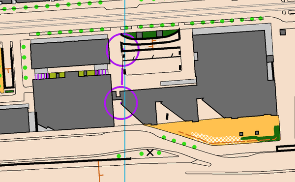
But should reading the control description be an important part of sprint orienteering? Kalle Rantala posted the map sample above on Twitter (see the complete Tweet below), suggesting to follow ski-orienteering and put a “clarification dot” in the center of the circle. Mårten Boström retweeted it – and both Boström’s and Rantala’s Tweets have gotten a lot of attention on Twitter.
Clarification dot – a good idea? What do you think?
Clarification dot for control location in #sprint by @SuunnistusSSL – something for @IOFOrienteering to consider? https://t.co/QR3bif83jR
— Mårten Boström (@martenbostrom) September 21, 2015
Suunnistus tapahtuu kartan perusteella. Kohdistuspiste hyvä joillain sprintin rasteilla. Metsämittakaavoilla eri asia pic.twitter.com/mhi9n5ACH0
— Kalle Rantala (@RanKalle) September 21, 2015
.@JornSundby Yes – needed information from map, not control description. Athletes, favourite if you agree.
— Mårten Boström (@martenbostrom) September 21, 2015
@martenbostrom I don't know when it can be used in IOF events, but I will work for it and support it.
— Jørn Sundby (@JornSundby) September 21, 2015


The dots are used in MTBO for years. And they are very useful. (In MTBO there is normally no control description at all! The control code is printed on the map, e.g. “1 – 131″)
So why not use them also in sprint orienteering? Or even in all orienteering events? (At least in cases where there are similar objects within the ring.)
It happens quite often that the description is subject to misunderstanding (e.g. “middle” [tree, ditch etc.] of 4 objects; or the symbol on the map is not the same as in the description). Often there are many details in the ring, sometimes the rings are not positioned exactly. It is often difficult to identify the actual control point or even to spot the exact center of the ring (during competition).
A dot would help anyway!
Ann.: In forest orienteering I would never leave away the control description, also not when there are dots!
In sprint orienteering there are many people who do not read the control description at all, as long as there is not an impassable object or the exact position is otherwise essantial for the route choice – myself included even as a veteran!
YES! No more crappy control description holders in sprint! They look ugly as hell and make the sport only much more difficult for beginners. They are simply not necessary in sprint orienteering when using clarification dots and when you print the control number on the map. Event for organizers it would be less work.
Dot: good idea. We have sort-of done it already within ISSOM by putting a pot plant (green dot) at the location of the control. You still have to check the description but it saves mentally rotating everything to figure out if left is north or south. Control code on a sprint map: bad idea, just creates clutter and features should be obvious.
Not a bad idea. But it’s very difficult to find a suitable place for printing the control code on the map (it is already difficult to find a good place for the control number)
Anyway this is less important than fair and interesting races on ISSOM maps
No!
It is really bad idea in my opinion, maybe it would be good to do so on forest races, but not during sprint. It is important part of sprint-o -> reading control descriptions!
You are right! That’s part of the game!
Orienteering is mapreading! Or should be.
If reading control descriptions is such an important part of sprint orienteering, why do world champions in sprint orienteering not bother to read them?
Do they not? The basic rule is always to read control description, it makes an entry faster and determines the routechoice (to see the flag faster). It would make orienteering easier but I do not think that it is the thing we want it to become.
Several of the top orienteers have said they don’t read the descriptions in sprint (like D. Hubmann, “In sprints I don’t read the descriptions. Each glance at the control descriptions is one less glance at the map.”) I think it’s good that you can win by just reading the map as it’s a map reading running race, not a little lines of cryptograms reading running race.
I ran an orient-show event in France (Aveyron) in 2008(?), and there the clarification dot was used and there were no control descriptions. This was in a forest area. Worked perfectly, but the scale was large and there were no control codes, so the map was not crowded with numbers.
Great idea. Older orienteers whose eyesight is not quite as sharp as it once was, will find the dot helpful in identifying the required direction of approach.
I am afraid “older orienteers whose eyesight is not quite as sharp” will have trouble seeing the dot at all…
Scanning down CD lists harder than the dot near my thumb for my ageing eyes. Definitely vote for dot.
I like the idea! However, they used them in the Finnish champs sprint (WRE) and I wasn’t aware that they would do so, then I didn’t understand what I was seeing mid-race and made a huge mistake (14th control in final)… but if they start to be used more then it would be definitely easier than finding an ambiguous description from a table while running at full speed!
Using dots as control markers in sprint or forest orienteering would be a bad idea.
Many point symbols are not fully symmetric, raising the question as to where to put the dot near a T, U, or X-shaped symbol. A dot 0.2 mm in diameter drawn on the NW side of a prominent vegetation feature (ISSOM symbol 420) on a 1:5k scale would erroneously indicate that the control is located as far as 5 m from the center of the object, leading potentially to wrong route choices. A dot placed on the N side of the X at the same distance from the center would make the control appear to be not directly at the object. In the case of line symbols drawn with dots, e.g., a small erosion gully (ISSOM symbol 110), control-marker dots would be confusing as well and hamper map readability.
Note that foot orienteering strongly differs from MTBO, which involves navigating along lines at high speed and requires significantly less complex map reading. MTBO controls are usually located anywhere on the line rather than on specified objects. In foot orienteering, reading the control description remains an essential part of the orienteering technique.
“would erroneously indicate that the control is located as far as 5 m from the center of the object, leading potentially to wrong route choices”
If control gets always placed where the dot is – here 5 m from the center of the object – how would that lead to wrong route choices?
The root problem here is the requirement for controls to be placed at a mapped feature. To describe accurate location we have had to have these control descriptions. The best and probably only way to solve this properly and for good is removing this requirement, allow controls to be placed “anywhere” not just by mapped object. Just place control where the dot and dot where the control is. And never place controls to a place where dot is confusing, like bottom of a pit, top of dot knoll or 1m from a such prominent vegetation feature style point symbol. Or too close to a small erosion gully. And no, this would not lead to controls placed in a thicket middle of nowhere style bingo controls. That can and should be stopped with other course setting rules and guidelines.
In addition, if you look at the map snipped you will see how those dots are not that legible for touching those walls. That’s result for the same requirement. There is be plenty of room to move the dot (and control) slightly to improve dot’s legibility, but we cant because we would not be able to describe the new location with control descriptions. By having just dots and flags where the dot there would be no such issues.
This discussion is a bit like the one after recent WOC – running on the edge (in this case read: not looking at control descriptions) does not always pay off. And that is the way it should remain. One can discuss if there shall be more ‘advanced’ control descriptions, but they MUST stay WITHOUT dots. If someone speaks about fairness, then fair = if everyone needs to look at control descriptions. Those who don’t can chose to do so, but may fail miserably.
MTB-O and Ski-O = orienteering ON the lines. Foot orienteering is about orienteering on the features and that is the beauty. Reading where the control is or is not located from descriptions if well planned can separate good competitor from an average and that is where seconds are gained or lost – that IS the beauty. I have witnessed that during various training and competition settings.
Not to speak of sprint relay when you don’t have the control description on your arm. By badly placed Control Description on the map, simply a nightmare. Dot forever!
I think many of us agree to the statement made by Mårten B that needed information should be found on the map, not the control description, but how to achive that is a question with more than one answer. We should not forget one of the main objectives of sprint orienteering, i.e. to create demanding legs between simple and distinct control point details. The competition should be decided between the controls and not inside the control circles. The course setter and controller/advisor should always keep this in mind and choose control details that can be found in high speed, normally without any need for reading the control descriptions. Instead of introducing another grapical element on the map, the solution is awareness in the course setting.
I think that clarification points is a very good idea. Reading the control descriptions is not a part of the spirit of sprint orienteering, and nowhere is it mentioned in the IOF rules about sprint orienteering. The IOF rules (appendix 6) state that “Finding the controls should not be the challenge; rather the ability to choose and complete the best route to them.” I can´t see that reading the control descriptions need to be part of finding the best route.
By using clarification points we can stregthen the special charachter of sprint orienteering against other forms of foot orienteering: “The Sprint profile is HIGH SPEED. It tests the athletes’ ability to READ AND TRANSLATE THE MAP in complex environments, and to plan and carry out route choices running at high speed.”
Furthermore I think that the clarification points in the images above are too small and too close to the other features on the map, RouteGadget provides a better example of how to use the clarification points: https://www.facebook.com/177518995597572/photos/a.180287198654085.49663.177518995597572/944728755543255/?type=3
To keep the “old school” happy why not trial having both dots and control descriptions ? I think pretty quickly you’ll find that nobody uses the descriptions.