 World of O News
The World Orienteering Championships is the major orienteering event of the year – an event were everybody expects top map quality, with maps drawn according to the international standards for orienteering maps.
There have been some discussions on the map quality for WOC 2016, however. Was the map quality for the WOC 2016 maps good enough? Were the international standards for orienteering maps followed? Below are some examples from the WOC 2016 maps. Take a look and make up your own opinion.
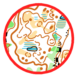
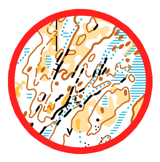
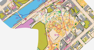
Small features on Sprint maps?
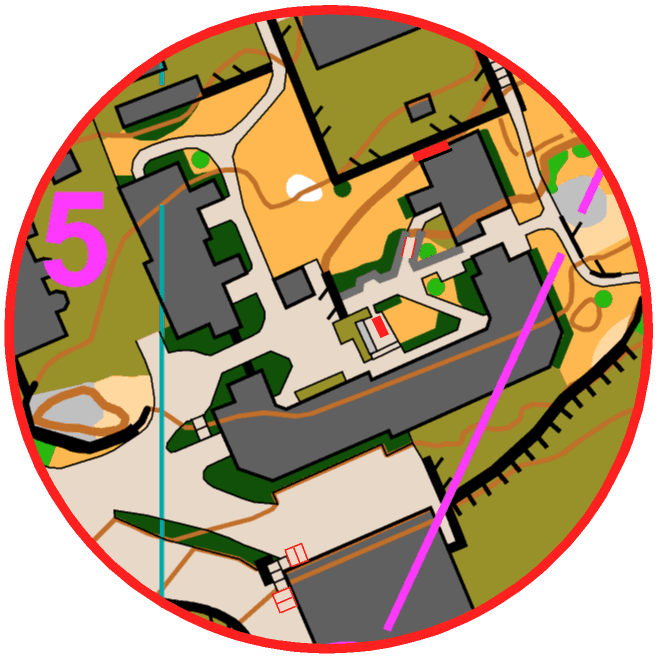
- The red lines are 0.4 mm wide – some openings are significantly smaller (Opening between house and fence in the upper right edge of above illustration is fastest route between control 11 and 12 in the women’s Sprint course)
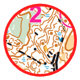
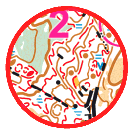
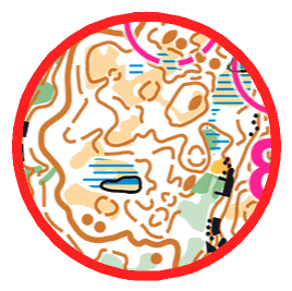
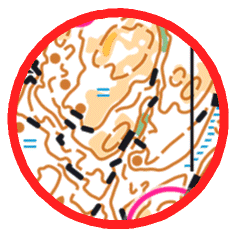
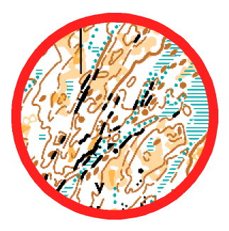
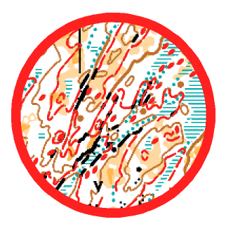
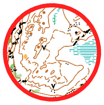
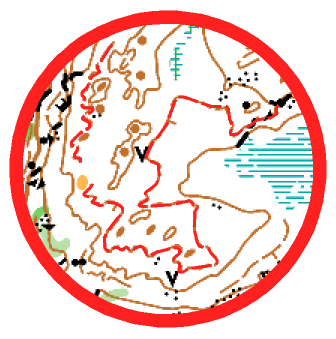
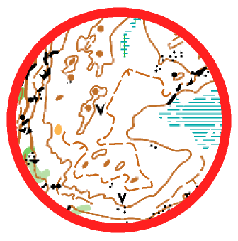
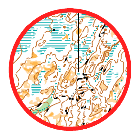
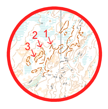
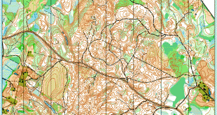
Middle map: (Too) Many formlines?
- The first illustration is the actual map. The second shows features of interest (do the extra formlines add significant information?). The third shows modified map with some changes
Case 1:

Case 2:

Case 3:


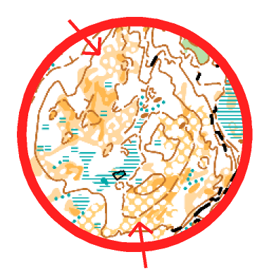
Middle map: Vegetation (too) detailed in open areas? Are 3 different colors needed?


Long distance map: (Too) many formlines – especially for 1:15.000?
- The first illustration is the actual map. The second shows features of interest (many formlines and small knolls). The third shows modified map with some changes
- The first illustration is the actual map. The second shows features of interest. The third shows the contour line smoothed.
- The first illustration is the actual map. The second shows features of interest (three levels of formlines).
Long distance map: Vegetation (too) detailed in open areas?
Credits for all illustrations: Matthieu Puech


Nice illustrations (and fixes), Jan and Matthieu. Thanks! Unfortunately there are many examples of this kind to be found on orienteering maps of today.
And when it is OK at the World Championships, it is OK everywhere ….?
The mentioned control leg on women’s sprint course was 11-12, not 10-11.
Tx! Fixed.
Nothing to say about the relay’s map?
Sometimes, 3 level of form lines are obvious : https://twitter.com/sim5907/status/768834625087139840
I think it is right to discuss this things. The detailed open area makes sence for me if it is clearly visible in the terrain and also the formlines look like they are drawn with purpose because they show many small features. Especially the difference between knoll and small hill seems usefull to me. Maybe on the 1:15’000 it is the right thing to simplify things. I think they did nice maps. However, it is hard to say just from the map and without checking in the terrain.
Phil: For me the small details in the detailed open areas were not clearly visible in the terrain. Definitely not at running speed, and sometimes not even when stopping to look carefully at the map.
Very delicate topic. I personally oppose all changes only on your computer. I saw what can mean a blindly simplified map. A simplification can be done properly only on the field. The line also has a role form very important (to draw all forms of relief between 1.7 and 3 m, with a slope greater than 20 -25 degrees, high enough to be easily visible) and can not be suppressed totally crazy, just to simplify. But there we have a derive much higher: 2,3,4 line form, sometimes without any logic. We must say a extremely determinate NO for these anomalies. Where will we stop? 7.11, & or who is the correct number?
https://www.facebook.com/photo.php?fbid=1214663861919737&set=gm.1050286941745800&type=3&theater
https://www.facebook.com/177518995597572/photos/a.180287198654085.49663.177518995597572/1424934877522638/?type=3&theater
https://twitter.com/…/status/768829287734583296/photo/1…
I agree with others that all the extra formlines do not help and are unnecessary, though that is not as problematic as small size of gaps on the sprint maps. That’s really a problem!
What do you think about the uncrossable stream on the relays? Lots of runners crossed it between the footbridges.
You are allowed to cross it, and you lost a few seconds when you crossed it. I guess it is OK, then? There was the same issue at the long distance where e.g. Gueorgiou swimmed across the uncrossable stream. There it was kind of strange at the map because the uncrossable boundary of the stream was removed to increase the visibility of some cliffs.
I would expect the runners to loose a few seconds crossing a crossable stream and much more if the stream is mapped as uncrossable.
Very detailed map is good for runners with good vision. I think nowadays with recent maps you cannot be perfect top o-runner with vision problems (using glasses etc.), because of reading map problems in high speed.
After age of 40-45 vision problems come to all of us (presbyopia) and e.g. in my case it has caused fall of passion to orienteering from 200% to 100% only…:-)
Especially in low light conditions (deep forest, heavy cloudy weather) you cannot read all important details in the map in high speed. Sprint maps with small gaps/passes between the buildings become even bigger problem.
Maybe in some years we will get maps on elastic “paper screens” (already under development), which allow zooming and seeing map details in bigger scale…
Making maps for Long distance race in scale 1:15000 should be different and more simplified than for maps for Middle… This is part of the game to interpret terrain from simplified map in Long… Too detailed map makes this race similar to Middle apart of some long legs with route choices…
Map should aim to to goal: to have a fair competition. If it’s too generalised it is not fair, but if it is too detailed, is that also unfair? Look at leg 2 on long. Those running straight could not possible do it good, too many details? Or why did so many lose time running straight?
I think you should note that Maths Carlsson says he will quit mapping for bigger events after so much critique, I guess especially from ppl that didnt visit the terrain. I have part in such, and this article certainly have too.
It’s OK to pinpoint problems, but when giving suggestions for solutions one must be clear that it is impossible to actually suggest this before visiting the terrain.
As for sprint, I think it’s easier, I mean a fence and a house, we can be pretty sure both should be on map so it’s the distance betwen them that must be changed. In the forest much more difficult to say the best solution.
Thanks a lot for your comments. For your information, I visited all the terrains, and so did Matthieu who prepared these illustrations. And of course I agree with you that the “solutions” shown here are only examples of how it could be solved in a way which gives better readability. Fixing a map without being in the terrain is generally not a good idea.
But: Not following the international mapping standard is not about visiting the terrain or not. If you don’t like the mapping standard, work to get it changed. But follow the standard in the work you do. At least when you make a map for the World Orienteering Championships.
I am fully on your side here Jan. If there are mapping rules, they should be followed. Its also clear that you can not reproduce an exact copy of the terrain with a map according to ISOM-maping rules.
We can also clearly see that there are a lot of different ideas inside the orienteering family about how a “good” map should be mapped.
Good that you visited the terrain, I didn’t realise it (maybe missed)! And I agree very much on the second part.
I am looking for instructions/exemples on how to draw contours, especially how to follow ISOM. A norm is god but not enough. Should also be a “handbook”.
Sometime it’s not necessary to going in the terrain for find the problems… https://www.facebook.com/photo.php?fbid=1214663861919737&set=gm.1050286941745800&type=3&theater And it’s not the only one example…Four line form?! Really necessary ? Where it’s logic? And tomorrow, 7? 11? Why another nation could respect rules and Sweden not?
Coti,
In general, I do not like too many form-lines for they make the map less readable.
In this precise example I would not mind them despite the fact that I’m a horrible purist. Here the form-lines simply tell what is seen by the map-maker smd the readability is good. In some other examples though, they make the map too crowded for reading, and the slope can be easily overestimated.
Actually it’s unbelievable how
A) the mappers of international events can simply ignore the international standards
B) the IOF controlers do not correct them according to the standards
and C) how it can be that those standards are obviously more suggestions than law.
Me as an athlete i train with and prepare for maps mapped according to ISOM/ISSOM. Getting a map at a world championchip which is mapped according to a random standard or even no standard must not happen and should be guaranteed by the IOF controlling system to not happen.
Right. Map is our playfield. And just like there is rules what the football field is allowed to be like we also have clear rules what out playfield – map – is allowed to be like. It is not about being perfect, it about following some simple rules.
Strömstad forest races were a lot like this match:
https://www.youtube.com/watch?v=rk9evgiqnKg
Same for everyone and from this perspective fair, but possibly not that quite that fair for those who have expected the playfield follows rules and does not have such playfields easily available to train with, because such playfields are strictly banned where they come from.
Fabian’s and Jagge’s arguments are really spot on. Why we don’t follow rules that we have been agreed on?
What is mapmaker’s, oraganizers’ and IOF controller’s answer to this? Are they brave enough to answer these very elementary questions?
It is sad to read and see all the critical remarks regarding the WOC maps. If Sweden, the most resourceful nation of all, cannot get the mapping right, then who can? M. Carlsson has the skills to make excellent maps, I do hope he will continue! The organizers of WOC 2016 in general did a large and great job, but still something went wrong. Comments that it is not recommended to fix the maps without entering the forest again is of course correct, but still it has been done. Morten Dalby, who lives in Halden and has a summer house in Strømstad, actually recently fixed Halden SK’s map around the their club cabin at Høiås. The map was mapped by continental map-makers and they had added several levels of dashed contour lines, similar to the WOC maps. Morten accepted the work to make the maps more readable on the clear condition that he was allowed to do everything from his home. The result was excellent, and has received favorable review by HSK elite runners!
Maybe you must reevaluate your position. Maybe less arrogance and more modesty could help you. Well, I think that nationality has nothing in common with the quality. However, I noticed the infatuation of many mappers Swedes and their supporters. For you, all others we are pseudo mappers and malevolent commentators. Perhaps it would be more constructive to learn to live with criticism and try to follow the rules. https://www.facebook.com/photo.php?fbid=1214663861919737&set=gm.1050286941745800&type=3&theater Now we have four line form,and it’s not the only example. If we do not take positions tomorrow we will meet 5,6,7form line and relief will no longer have any sense.
Doing a map is a tough job. Everyone who once tried will agree.
It’s tough, and it’s frustrating, because whatever you do, no matter how many hours you spend on the terrain/computer, the map will never be perfect, or even lets’ say “homogeneously good”.
The idea here is not to say the map is bad, or wrong.
The idea is more to question whether it’s good or not to have more and more detailed maps, playing on the edge of what ISOM/ISSOM says is correct (mostly because of new technologies helping the mappers). With Laser data, the challenge of mapping have surely moved from mapping correctly (all features in right place) to mapping with homogeneity and good legibility… which is also much more subjective/debatable.
Matthieu, I agree with you when it comes to forest maps. If you don’t follow the standard for Sprintmaps in urban terrain, and you don’t draw a gap of at least 0.4mm between the object, then the map is bad. It’s simply not legible in competition speed. There are many more examples when it comes to sprint maps in urban terrain e.g. contourlines on stairs(*), using index contourlines (they are too thick and you don’t need it for sprint), small olive areas on yellow without a black line around (you simply don’t see it), in Lysekill they used a new symbol for a wall with a fence on top… introducing a new symbol at a World Cup event, what the…?!?
I believe on Sprint maps mappers have to strictly follow the standard, and if necessary not drawing how it really is, but draw it the way the runners can read it, e.g. draw a house a bit smaller that the gap to the next wall is wide enough.
(*) One interesting issue with the WOC 2016 Sprint Final map: On the printed competition-map there are some (not all!) stairs with contourlines crossing them, even index-lines, what can easily make you believe that there is a wall or a fence when you run full speed. But if you now check the digital version they uploaded to the woc homepage (http://live.woc2016.se/blog/2016/08/20/352/) and the gps, all the contourlines crossing the stairs are cut away and the stairs are free… What means they uploaded a better map than they printed! How the hell can this happen at WOC? Can’t be a printing problem with different colour-layers since some of the stairs are fine on the printed map… Would be nice to get a statement from the organisers and the controller about that…
I think that countours being cut away is just result of overprinting effect. Web image was exported without overprint effect but paper maps was printed with the overprint effect. Similar thing can be seen in WOC middle map 2015, blue stream on top of brown road next to second last control. It can be seen in printed maps but it is cut in tracking map.
Yes i agree with you Fabian. I was talking only about forest maps. ISSOM gives less room for interpretation, so basically a sprint map is more likely to be “wrong or right” compared with a forest one.
Completely agree, Matthieu!
Recent technologies make possible to prepare maps more perfect, with more details, but overall outcome is always subjective and depends on the mapmaker.
As I wrote, interpreting the terrain reading from the map in high running speed is one of the main goals of this sport. Maps should be well legible in running speed (without any zooming on the screen or stopping in terrain).
ISOM/ISSOM (and other possible new norms) will never give 100% rules or guidelines how particular terrain for particular O-discipline should be drawn on the map.
In big international O-events it should be regular responsibility of the course setter to communicate with mapmaker and advisor to make additional changes on the map, which avoid unfair situations for runners on particular courses/legs.
I completely agree with the sprint map errors, but too much details on the forest maps????? What are we talking about? Do you want back to 1980? What issom rules exactly are broken by introducing these form lines??
If the terrein is as detailed as it was in Strömstad it should look like that on the map as well. As an elite runner you should be able to filter the information given on the maps. I ran on the middle terrain and I am standing 100% behind the WOC maps.
As a last thing, speaking about IOF work and quality controle, there are enough thing to do for IOF rather than worrying about “too” good maps, for example, making world cup more attractive or spent a bit more resources on doping control.
Sergey, to answer your question “What isom rules exactly are broken by introducing these form lines??” It’s the definition of the symbol “103 Form line” given by ISOM that is ignored:
“103 Form line
An intermediate contour line. Form lines are used where more information can be
given about the shape of the ground. They are used only where representation is not
possible with ordinary contours. Only one form line may be used between
neighbouring contours.
Colour: brown.”
It sais ONLY ONE formline may be used between neighbouring contours…
So, what is the problem? What I see: one form line between neighboring contours, next form line between NEXT neighboring contours… It is how interprete the thing. No rules are broken in this case.
There was huge number of situations, with up to 3 consecutive intermediate contours in WOC maps. In some cases it were even impossible to indicate the slope direction of such contour. See article above and mass of other comments!
Ok, I see, in some cases the mapmaker was a bit too enthusiastic about the amount of the detail in the forest. But Jan showes a lot of examples within the rules which makes it a little bit ambiguos.
In the end rules are the rules and should be followed. This “map problem” however was not as big as last years before last control situation on the middle which actually costed people medals, so I dont really understand the point of it, if there are much bigger troubles within orienteering.
I leave it here with your gossip :) and I go for a run on the “bad quality” Matts Carlsson map.
I fully agree with the position “ONLY ONE formline may be used between neighbouring contours…”.
Using of multiple formlines shows the inability of the mapper to correctly interpret the surrounding terrain.
And after that, unfortunately, many runners start to take this approach in cartography as normal :(
Expressing personal opinions are always fine, but when making bold statements regarding the maps not being ISOM compliable it is better to first read all parts of it:
In addition to 103 (form line) there is also 111 (knoll) and 114 (depression).
It is nowhere stated that you cannot have 111 (dashed) atop 103, or 114 (dashed) below 103. You are of course entitled to opinions, but it is not breaking any rule in ISOM per se. I’m pretty sure the mapper considers the third level on the example a knoll.
Furthermore, ISOM only states that that you may only use “one form line between neighbouring contour”. It does not state explicitly that you cannot use several levels, if there are no “neighbouring” contours, such as on a top level of a hill or in a flat are. Again, you are entitled to opinions, but before you need to prove that there are really two contours around it that really are neighbouring.
Note that I am not commenting on the amount of form lines on this specific map, simply pointing out what I consider an over interpretation of ISOM that has been repeated too many times.
And that’s entirely not true. ISOM chapter 4 explains “features” and “symbols” (very first line there). 103 is a “symbol”. There is symbol definitoon (line width, gap/dash length). And text telling how it must is used to draw “features”. One of those “features” is 111 knoll. Knoll is not a “symbol”. Note, line width and everything is missing. It is just one of the “features” drawn with these contour type of “symbols” (101/102/103). Everything written about those symbols apply when drawing knolls with them. Of course, knolls are one of the most common and typical features we draw with those symbols.
In addition, claiming only one form line between neighboring contour means we are allowed to draw as many form line as we like to te top of the hill above topmost countor and also under lowest contour at the bottom of a depression, that is not only a strech or wrong, that reveals something more. Especially when perfectly sane and intelligent people do this. This phenomena is called Denialism https://en.wikipedia.org/wiki/Denialism Some avoid this uncomfortable truth by making up these silly claims (that everyone else immediataly sees being just nonsense) and repeat them until they start believeing it themselves. Some do the “all others do it so it’s ok for us to do it too” claim (even if latest 5 WOCs only 2016 has these form lines), similar to the claim often used to support doping. And some just quickly thik something else to forget it and pretend problem does not exists.
It is clear that you have you have made your own almost religious beliefs on what ISOM is stating, and prefers to mock those that have different opinions. It is typically futile to reason with such people.
A standard is a standard. Anything within reasonable interpretation of it is not breaching it. If ISOM2000 really intended to change an age old way of drawing form lines, it was surely stated in a most convoluted way. If these were considered unintended loop holes, and the MC was united, it is highly surprising that they not in 16 years have clarified it…
There may of course have been too many contours, or too little generalization on the maps, but that is entirely another story.
Most runners have ran a lot in Bohuslän last year. On official trainingmaps, in selection races….
Were those maps made in another style? If not, have there been complaints? Did the WOC-runners meet a mapping style they were not prepared for?
Thierry Gueorgiou (at interview after the Long) : ” (…) how is it possible that we discover the map makers only one week before the championships and we get no map which is made by this map maker. My routes were according to what we saw at the model event only two days before. “
I´m surprised of TG:s comment. I have known the name of the mappers for more than two years, and so have all swedish runners, I guess. So why not TG?
Of course it´s not always possible to train on each mappers maps in terrain similar to WOC, but as far as I know, these mappers are mapping in a very similar way.
But most important, did the runners really meet another mapping style than they met on training maps?
Actually – the discussion is about rules and so no one has a duty to be familiar with a particular maper and his style! ISOM is the item. And accordingly, everyone has opportunity to hope that map will be drawn based on ISOM! I see that root of the problem is in dangerous loosing of some gold principles of cartography in orienteering maps. And it appears ewerywere in orienteering world, not first time here in WOC. While orienteers will accept this, it will be the problem.
It was not written in early Bulletins. Fair?
Was the name of the map makers not written in any Bulletin prior to Bulletin 4, which was published just a few days ahead of the championships, while many others had the knowledge? That can’t be right? Surely I have misunderstood your comment, Zerbembasqwibo?
The bulletins are available here:
http://www.woc2016.se/sv/taevlingar/woc/bulletins
The mappers were presented in Bullentin 4. In Bullentin 3 you could read about the model event:
“The Model Events will provide an area and a map relevant to the WOC competitions.”
There was a news on the WOC homepage during last winter about the WOC mapping team:
http://www.woc2016.se/en/news/302-mappers-of-woc-2016
That was the only “official” communication about mappers before the bulletin 4.
But, the main issue is that no training map provide by the organizers were made by one of those mappers. We can always argue that it was the same for everyone, but in my opinion, it should not be like that.
It was also the first time in history probably that the warm-up maps were made by another map maker (Göran “Muhammad Ali” Olsson).
We´ll never all agree on what is a good enough map or a good map maker BUT at least the athletes should be able to prepare (in advance, not 3 days before) for the style of the choosen mapper to adapt their strategy.
@ Thierry Gueorgiou You are talking about really important thing!!!!! That’s the crucial thing – to get training maps which: 1) represent relevant terrain, 2) have same drawing style. Lets us organize petition about this! What do you think?
Normally if there is a special feature on the mapped area or typical for this type of the terrain or special construction on sprint map as Fabian described “wall with a fence on top” I would expect to have this recorded in IOF controller report and why this happened. Logical solution which is normally used or organizers do it is A) present this feature on team meeting and B) have written down as a special notes for the terrain description available to runners. If controller spot this issue I would be interested to know what was the proposal, how should be drawn and what was the final conclusion. Same for ISOM and uncrossable stream. Did Athletes have this information to know that before the race? If the whole controlling system should work in athletes favor I suppose the template “controller report sheet” should be updated because apparently is not good enough or the SEA controller did a poor job or miss this because of fixing other issues as well and time run-out. Controlling WOC maps is so much important for all and I would expect that controlling team should consist of SEA, national controller as today + ex elite runner. Who reads SEA reports, how others can learn on these mistakes?
Some notes:
1)ThemainissuewiththisyearsWOCmapsisnottheexcessofformlinesbut … (okay I assume you got my point :-) The main issue with this years WOC maps is not the excessive use of form lines but the lack of graphical generalization as described in subchapter 2.4. of the ISOM2000. It consist in focusing on the maps legibility by adopting certain minimal standards in regard of minimal sizes and minimal gaps plus using the defined symbol set. Just for example a collection of legibility infringements just on this small excerpt of the middle final map
2) The Swedish MC introduced back in 2014 the so called technical control of high level event maps just to assure that this focus on legibility ignored by many Swedish mappers shall be reestablished. While most mappers would agree that legibility is the basic and most crucial quality of a map, this measure taken by the SOFT met broad opposition by most of the high profiled mapper in Sweden. Among the strongest opponents were just the mappers in charge for mapping WOC 2016.
3) As for the WOC 2016 maps the Swedish MC and its control mechanisms were locked out under the pretext of secrecy. Thus: no national map quality control could be done. (The head of the Swedish MC stated at the ICOM that these maps would not have passed their map control)
4) Neither was the IOF MC involved in the mapping process. Officially the IOF MC assigns a member of the MC as map advisor, but its advise was obviously not asked for. How other could it be explained otherwise that under the ICOMs map walk the members of the IOF MC easily pointed out all these major map issues? So the IOF MC was neither involved. [Worth to mention here that already in late 2014 the IOF MC chairman was personally informed that they shall seek involvement for these issues where easily foreseeable]
5) So who was actually in charge for map quality control? First there are the mappers, of course! Then it surely is the organizing committee, assigning the mappers. They can not just leave all the quality control over to the mapper (which they actually did). And finally there is the SEA. At ICOM a mapper of the WOC 2015 stated that the SEA indeed was the only person discussing mapping quality issues with him. In regard to these years maps one might ask if he is the right person for just that job (I ONLY point to map controlling!). Furthermore it appears that the SEA himself gets involved with the map at a pretty late stage, as in the case with WOC 2014 in Italy where issues only where spotted in winter 2013 and fixed by the SEA himself as late as may 2014. By the way, it happened before in 2011. There also the SEA/IOF MC intervention came much to late.
So the conclusion: If we want to avoid such scenarios in the future a proper map quality controlling system must be established by the organizer over the entire mapping process. National and international MC shall be involved.
Some sentences from Orienteering mappers group discussion in Facebook.
– I cann’t find the title of „IOF Map adviser” in IOF rules and the name of „IOF Map adviser” in WOC bulletins…
– Mr.X just mentioned at the ICOM that they where NOT ALLOWED TO CONTROL the map. They would not have accepted it…
– Very very very very terrible thing!!!!!!
– IOF MC must change and improve quality control for future…
– Well, we look forward to MC’s opinion on these intentional and repeated failures and deviations from ISOM rules…
– MC should have something to say in this story. They are no longer able make ostrich policy.
I only had a look at the very latest IOF Competition Rules so there may be some differences with earlier versions. However:
1. The name of the mapper is not mandatory information in any of the Bulletins for an event. Not even Bulletin 4!
2. The responsibility of map control is clearly with the Event Adviser, SEA for WOC. Assistant Advisers can be (and are) appointed but its not clear what is the division of labor between them.
3. It is not clear to me what the National Adviser is supposed to do.
Some comments:
– The IOF Competition Rules would benefit from a comprehensive edit. There are spelling errors, missing references not to mention the factual shortcomings.
– The SEA has a lot on his table and presumably a limited budget to work with. I have the feeling that sometimes the SEAs are more concerned with services for the TV production (including demanding rather than approving a 2 min start interval in ling races) than providing quality for the runners.
– The role of the National Adviser should be to ensure that the control functions are not less rigorous for international races than for national races.
– I do not think any organizer has ever put up an independent map control apart from the interaction between mappers and course planners.
– Otherwise the division of work seems fairly ok, the Map and Rules Commission set the standards and rules and the Advisers (with a team) ensures they are met. Some clarity is needed though.
I am a little bit surprised that today’s elite runners complain that the WOC2016 maps were too detailed. Even I can read them (on my PC).
This one, however:
http://www.baath.de/doma/show_map.php?user=veikko&map=1175
I cannot read on my PC even at a 500% zoom ….
… and I have seen a few maps like this – different greens, yellow, stony areas with a lot of contours – all mixed together … impossible to read even at max zoom on the PC.
But I did not see any complains from the elite runners. How can you read this a max speed?
For me this is difficult to understand …
Off-topic. Title of this post : “Were the WOC 2016 maps good enough?” implied, “for a WOC competition”. No WOC were organised on the maps you’re mentioning.
Yee, you are right. But the same international standard applies to all maps, right? There is no special WOC standard?
The WOC is the most important event of the year, and of course this event should have good map quality. I’d say it is worse if WOC has maps which are not up to the standards than a summer-holiday race in France? But I appreciate that you want those maps to follow the standards as well.
Unfortunately there has been a tendency to more and more maps/mappers not following the international mapping standard the last years – especially with accurate LIDAR data making it easy to make very detailed maps. Instead of working to change the standards, the mappers instead make their own variants of the standards (“local standards”/”personal standards”) – because they think that this is better than the international standards in this terrain type.
It might very well be correct that the local variations work better in some cases, e.g. for (local) runners who are used to these “local standards”. In other cases the mappers have some “good ideas” which don’t work at all. The international mapping standards are there so that you know what to expect. If you don’t like the international mapping standards, work to change them in the forums available for that. But follow the rules when making a map. Especially if you are making a map for high level events.
Thanks Jan.
I agree to everything you said.
But from what I have read so far, it does not seem to be the actual quality of the maps that was the problem.
It seems to me that the problem was that the model event and the warm-up maps were not made by the persons who made the actual competition maps? Therefore the runners could not really know the mappers interpretation of the international standard. Of course, this could impact their decisions during the race.
I can also see a few instances where the use of form lines is not according to the IOF regulations. But how would this affect the runners?
And there are no rules that stops you from using 3 different colors to map open areas?
My understanding is still that what you see on the map is what you see in the terrain (or vice versa).
Is my understanding correct, or … ?
Please enlighten me.
@old & confused: There are two issues with the forest maps from my point of view. One is the actual rules which are broken (e.g. the formlines), the second is the map legibility which in my opinion, having been in the terrain and used a lot of time studying the map, could have been a lot better without losing any information significant for the runner, even at walking pace. I think o-zeugs catches the essence quite well for the second part with his comment further up (see also there for a link to map sample): “The main issue with this years WOC maps is not the excessive use of form lines but the lack of graphical generalization as described in subchapter 2.4. of the ISOM2000. It consist in focusing on the maps legibility by adopting certain minimal standards in regard of minimal sizes and minimal gaps plus using the defined symbol set.”
So I’d say you can get away with a lot of the issues with the forest map by saying it is just the mapmakers different interpretation of the rules, but not all of it. The same with the sprint maps (although there the rules broken are very clear to see). And yes, as with most “local/personal standards”, what you see on the map is what you see in the terrain.
The fact that the model map and the competition map were made by different mappers is a different issue which is not my main point in the discussion. However, this might have influenced the runners more, although this would be only speculations. The discussions of course get complicated due to the fact that there were several issues with the maps at WOC 2016…
@Jan: Thanks again. I am starting to get the picture …
… and it is Saturday evening … midnight … we need to get a life! :)
@Old & Confused: Agree with Matthieu here, the main question in this article is if the maps have a sufficient standard for a WOC.
However, as an aside, in some cases/terrains you lose a lot of useful information by generalizing. In the WOC terrains however (I was there and checked), you could in many cases have redrawn the maps with a lot better legibility without losing any useful information even at low speeds. One example is the use of formlines. The complex, detailed shades of yellow were very difficult to identify in the terrain, even when stopping/walking – not to mention when running. A third example is how the contours are seemingly taken directly from LIDAR-data without redrawing them using Bezier curves, giving many small details which are not useful at all.
EDIT: I just got information that the contours on the WOC maps are indeed all redrawn, the problem is that they are redrawn with lots of points instead of using beautiful Bezier curves.
Sorry for being off-topic.
Based on these posts I can see that there are a few places where the maps are not mapped 100% according to ISOM/ISSOM (middle and long). To me this looks minor (but I am not an expert). You actually give the runners more information than they should have! However, I agree that the international standards should be followed.
But what were the impact? Did somebody lose a medal? Or did somebody win a medal who shouldn’t? Or, … ?
http://www.attackpoint.org/viewlog.jsp/user_15725/period-7/enddate-2016-08-28
“I felt prepared. I was not.
I have maybe never felt that relaxed before a WOC race (too relaxed?), but the truth is that I understand not much the terrain and the runnability. It doesn´t comes naturally, and I quickly get frustrated. And for those who wonder why I choose this route for the 12th control, I recommend you to visit the model map and check the runnability in the “yellow with white dot” (symbol 404) there. Once again, we all had the same map, and I will not blame somebody else. I was not good enough. Dot end.”
Old&Confused: Thank you for the publicity! I’m so grateful and I feel indebted to tell you a secret: Well, it’s seems that runners do not like at all to meet in the field things that are not drawn on the map, or are drawn wrong.Worse, runners hate to not find on the ground some stuffs drawing on the map.Now about your example: I wonder like you how they were doing in such lands. But it seems it’s doing well and really them enjoyed. Most importantly, as you noted, is does not complain about. Notably is that is not a map-land for WOC and not ISOM. But we the mapmakers sometimes we’are as tailors who work with the material and desires of the customers. Now, if you want to compare cliffs 20 meters high with land-forms 1 meter in height, you’re my guest. I hope now you’re less confused.
I want to tell you how much I enjoyed your detailed and clarifying answer. I have been reading a lot about mapping, map standards and WOC 2016, and your excellent feedback made it all come alive for me. Those of us who have ancestors who started orienteering in this region are especially grateful for your contribution. It was thoughtful of you to add those personal observations. Your answer also gave a great boost to our efforts to recruit new, young mappers. Thank you very much for an enlightening and stimulating advice. Your articles helped me realize that our problems are typical, and we can solve them in constructive ways.
Again, thank you for your thoughts and clear writing.
:)))
Maybe I was a little arrogant, and I apologize for that. I forgot that light comes from all “who have ancestors who started orienteering in this region”. I think I should reconsider my competencies. I must admit that I never was able to drawing the relief with 2.3 or even 4 form line. I think I must come in yours terrains to learn this because it seems to be extremely indispensable. And maybe, who knows, someday the student (I) will overcome the teacher (you) and beginning to be able drawing the relief whit 5,6 or 7 form line. Only in that moment I will be worthy of your praises. I look forward to an invitation. Thank you also.
Your comments more than suggests “Death to the infidels” and is taking this discussion nowhere. There is already enough radicalism in the world. Why all this aggression?
I would like to encourage the “inqusitors” to post maps they have actually surveyed in relevant terrains to show how it could be done. I am quite sure most people who has surveyed Nordic terrains occationally have been /tempted/ to use more than one form line between two contours in certain areas, but resisted, as we all should draw our maps according to ISOM? It would also be nice if base maps were included as background for the final map, along with a statement of *why* the form line was drawn along that particular feature, and not along another proximal equally prominent feature.
Also, if those who are in favour of using excessive form lines also could provide maps and basemaps and state why more than one form line have been used, it would be great (the climate of this debate suggests that some extraordinary levels of stamina is required to do this).
This could be an highly educational exercise for most mappers, I guess. As Thierry G has tweeted: “Knowledge increases by sharing but not by saving”.
@ Amateur mapper I think radicalism, born radicalism only. When I see that those who should recognize that yes, it was an error, we’ll be more careful next time,they only find this normal and do nothing to attack all those who say it’s an anomaly, it is normal to get angry. What normally find in not following a rule so simple?!? “Only one form line is allowed between two lines”All other comply with it, only the Swedish mapmakers say no . Moreover, I find it normal. I ask again: If a nation so great not comply with a rule so simple, what can we ask for others less?. Be a big nation of Orienteering that will give you more responsibilities, not more rights. You have the responsibility to be an example, you have no right to deliberately violate the rules. Of course there are also unintended accidents, but here we are dealing with an intentional and repeated violation. I will ask a question: Now you have interpretations with four form line. How many you would needed more in the future to interpret correctly the relief ? I do not think there is a ground that can not be interpreted only the with a line form. I am ready to prove to anyone, anywhere. And me, I’m sure there are hundreds of mappers. P.S. I greatly appreciate those who debated with their true identity. I have already been contacted by several people in private what I have suggested that my posts bothering. I answered only the those with true identity.
Don’t forget: “the print quality was horrible with many runners getting their maps ruined with problems to see the controls”.
“Perfection is achieved not when there is nothing more to add, but when there is nothing left to take away” — Antoine de Saint-Exupery
I found this discussion kind of strange in a way. Is really this years maps worse than many other WOC maps? The discussions seems to imply that but I kind of doubt it.
Some points:
ISOM, all WOC maps I have looked at for the last years don’t follow ISOM. The most common problem is to small areas for some colour screens. Take for example the following map from Finland
http://www.gustavbergman.se/doma/show_map.php?user=Gustav&map=1379
There are a lot of way to small gray and yellow areas and some ridiculous small 404.
Is it ok with to small areas according to ISOM but definitely not allowed with more than one form line? (even though that number of form lines is often ambiguous?) There are also multiple form lines on that map but they might be allowed because they might be at the same level or something like that.
I found it quite strange that the number of form lines is massively criticized this year when for example the WOC maps in Finland also have a lot of form lines.
General legibility. I have problem to understand why this years woc maps should be criticized for that compared to many other WOC maps. Was for example this one really better?
http://www.woc2014.info/LIVE/maps/middle/%D0%A1ampomulo-Middle-M.jpg
I understand the discussion if it really is about trying to get better and more legible maps in general and the procedures needed to get there but for me it seems to be to much about this years maps even though I don’t believe that they are any worse than many other maps at high level competitions.
There is no reason to think that this discussion is strange or untimely. The problem really is not new, and not only of this year maps. And previous conditional silence does not mean that everything is going right. Obviously, this year, finally patience was exhausted. The oddities, which one can seen this year, but mostly the some of comments about this, sometimes causes worry about – is it still orienteering? I am sure that while developing ISOM, there was prepared sufficient justification to ensure that maps will correspond to the definition of O and rules of O. And nobody here has so far not tried to challenge the definition or rules. It appears, that people who have their own interpretation does not even attempt to reconcile it with the existing rules! Then it is may be not only denialism, but more complicate case. Such the philosophy and behaviour leed to the dead end. In form of further detailing, in form of making map even less legible, in form of distancing from orienteering at all. Soon we will come up with maps of scale 1:500 with every tree individualy shown on the map! Next will be underground facilities. Because the “map maker” will interpret this as an important objects for navigation. With emphasis to the importance for “map maker”, not to “an athleete”.
Strange feelings take over when you find out an opinion of “mapper” that the contour can also be the last or outer one, or that information quality given on the map has minor importance for athlete’s sucess. Where is Your elementary knowledge of cartography and common sense, dear mappers?
The maps failed on many fronts this year, not to mention the printing issues. The quality of event organising at this level has seriously degraded in the past 10 years. I feel it maybe due to the fact that organisers put too much focus on the ‘frills’ of orienteering and forget that the essentials are the most important thing. It’s like finding out the olympic track was actual 393m around.
I really don’t think there has been a general decline, in particular the JWOC we held last year in Telemark got excellent map reviews from both competitors and the Event Advisors, as well as all the people running the public races.
The main/only problem we had was the fact that we weren’t allowed to show the Ant Hills (118, brown cross – special land form feature) on the one map where they are very common. It forced us to move about 8 controls on the Middle map but I don’t think anyone actually noticed this during the events.
https://goo.gl/photos/7RW2ifTuTWQ5scou9
Thanks Terje, but you’re talking about 1 event here out of 10 years, and by the sounds of it you were an organiser in some form? Granted it may have been ‘one of the good ones’ but try not to take my opinion personally. How many World Cup level events have you been involved in in recent years? I’m sure you’ll find a lot of runners who have noticed the same trends as I have. The most obvious example was EOC in Portugal, which was an embarrassment for many – IOF as much to blame as the organisers.
I’m not saying that I don’t agree with the initiative to try and get more exposure for orienteering through TV production, but I think that IOF and event organisers aren’t well enough equipped to deal with the requirements for such a feat. It is at the point now where it is seriously impairing the quality of competitions – both directly (choice of terrains and courses being compromised for better TV coverage) and insidiously by not leaving enough resources for quality control resulting in blunders/oversight by organisers/IOF such as poor mapping quality, poor printing etc.
I’m not saying that TV production is the sole cause of all of our problems (some other technologies have caused issues as well), but it’s hard to pinpoint where top level orienteering took a turn for the worse. The common denominator for me seems to be the introduction of TV coverage of the competitions.
This TV production can be done, and is necessary, but I think it should not affect the quality of the events. I can’t offer the perfect solution, but one would be to put this as a secondary focus for organisers or perhaps scale back a bit. Make sure the basics are right and then worry about the frills.
@WOC Runner: I agree with many of the views posted here, in particular I think that we should have realized at least 2-3 years ago that with big screen GPS tracking there is really no need for arena passages!
I.e. when the terrain is suited for it, with good forest on both sides of a relatively short arena passage that is the only way to link them, then by all means use such a passage, but otherwise keep the orienteers in the forest, orienteering.
I was indeed involved with JWOC 2015 from the very start: I developed all the base maps for both competition and training maps, so map (and course) quality is what I’m most concerned about.
To me there are just a few crucial issues:
At which scale is the map readable? If the terrain is too complicated to allow even a master mapper to depict it according to the ISOM standard while maintaining at-speed readability, then I personally believe we should allow enlargements instead of stating categorically that “such terrain is unsuitable”. Generalization is still crucial but Shannon’s Sampling theorem still applies: We cannot simplify/generalize so much that the actual terrain disappears.
Making an orienteering map is really an exercise in compression – we’re trying to convey the maximum amount of useful information in the smallest possible amount of ink. :-)
Is the mapping fair? Unless the map makes it at least possible (it might be very hard!) for runners to determine the best routes, then we introduce a large element random chance.
I believe the great 2nd leg of WOC Long might be in this category simply because it came before the runners had any time to experience both the terrain and the mapping, otoh I also believe these courses will win the end-of-year voting on the best Long distance courses of 2016.
As TG complained, there should have been model maps of similar terrain, developed by the same mappers available to the competitors before each event.
Some comments about the 2015 maps…
Like most countries, Scotland has evolved its own mapping style to suit our terrain which is different from Scandinavia where standards are set. Sometimes we break ISOM, but if we do, we know why: e.g. we have few boulders, so small ones under 1m are distinctive and mapped. Vegetation is very different in summer and winter, so we (should) have two maps. So when WOC comes around, should we…
a) Map according to local interpretations, runners have to learn it from existing maps.
b) Map according to IOF interpretations, producing a map different from all training maps.
You might ask us to make lots of IOF-interpretation maps, but we have neither enough terrain or resources to do that. I’m really interested to know what the athlete would prefer?
So what actually happened? The first draft (middle/relay) map was a minimalist ISOM with all small features removed. Then the mapper got fired (I don’t know why – nor does he) and the new mapper put lots more detail on – still within ISOM (e.g. vague clearings but no undersized rock). But time ran out, and there were many inconsistencies, so the clearings came off again. But crucially, the decision of green and green stripes kept changing, so the best route was one week mapped as green, the next not (and, remember, the stripey green showed vegetation which hadn’t grown yet).
To me, each and every version of the map was clear and usable. But the continual changing of styles meant the available training maps became less relevant.
In Central Europe we have the same issue with ISOM interpretation on national level because of typical continental terrain characteristics. For example Czech national mapping standards are much higher (more detailed, especially with respect to different vegetation types and boundaries).
E.g. at WOC 2008 in Olomouc (CZ) the maps for WOC were made in IOF high level standards (ISOM/ISSOM) (e.g. http://woc2008.orientacnisporty.cz/files/images/scontent/maps/middleF/middleF_MEN.gif , http://woc2008.orientacnisporty.cz/files/images/scontent/maps/longF/longF_MEN.gif), but same maps for public competition in the same terrain were done in national mapping standard (more detailed) – sorry I cannot find links to the maps – and the differences were really notable… (Public race was done on better map than WOC 2008… :-D )
But I 100% agree that the IOF mapping standard must be the same for all high level IOF competitions, regardless of location and mapper… and must be usable and well readable for runner during high performance…
Runners expectations are fixed in ISOM. Mappers performance are fixed in maps. Quality (by definition) is comparison of expectations with performance. We can not talk about the fair play and quality if map was not prepared and printed according to specification. And, btw, – ISOM allow deviations, but deviations need approval.
The main problem is trend of mapping – from „only one form line” till „four form lines”. What’s next? Quo vadis IOF? How it is possible to „not allowed to control the WOC map”?
It is dead end… and it is time to change the course. Let’s ignore rules at all or let’s improve quality control for IOF events with more detailed instructions, educations and real control. Great challenge for new President, new Council, IOF MC and all national federations.
I really don’t understand the importance of this “four form lines”. It is one example and you find four form lines if you run parallel to the ordinary contour. Yes, they might show distinctive slope at four different height levels but they also might be at the same level. A single form line or contour can also show slightly different height levels.
I just think that it is a huge difference if you pass four form lines while running perpendicular to the contours that are relatively closely spaced and passing four form lines while running parallel to the contours over a relative flat area.
The solution to this “huge” problem with four form lines is of course to join them together and ad form lines where necessary so that it looks that the lines are at the same level. Some more lines might be more ISOM but maybe not more legible.
https://www.facebook.com/photo.php?fbid=1214663861919737&set=gm.1050286941745800&type=3&theater This is one example. Please join them. Yes, it’s a huge difference.
@beginner There are several consequences isued from statement of “only one form line” The main of them : if an athleete found two consecutive form lines, then, according to this statement it logically lead that the second one must be with opposite slope direction (or – it must be parts of one, closed form line). If not – then it will carry misleading information about slope direction. And it definitely is not fair.
The next consequences consider capabilities of athleets to read and perceive such forms during race load. There is great opportunity to exaggerate human capabilities and actual need of this.
How can you read that from the description of form lines? I don’t understand why “one form line” can be several lines if their slope is different. Or should “one form line” be interpreted as one level of extra contours and that the level also need to be “closed” so that you always change slope?
That “interpretation” make sense but the description is quite bad if that is how it should be interpreted.
I also believe that it is also quite common to the see form line knolls above form lines in many countries and those has the same slope as the form line around it.
I believe that this discussion to some extent is about the meaning of form lines. Many map makers seems to see the form line as an optional 2.5 m contour but I believe that many Swedish map makers see form lines as showing distinct slopes in the terrain and those can be at different levels in the terrain (not just 2.5 m) and it might also be useful to just show the part with a distinctive slope (so that the form line is broken even though some of the terrain “passes back through” the altitude)
I believe that the first one is the best interpretation in many cases but I cant see that it is clear in ISOM what is really meant by form lines and how they should be used.
Still I don’t really see the problem with form lines that might have the same slope a long distance from each other.
See case 2 on illustrations in the article above. In lower right part there are two streches of form lines between contours. As well as there are knolls shown using closed form line. Let imagine that knoll is much larger, and inside extracted portion of map you can see only parts of this – for instance – N and S. Then N part will be with slope forward while S – in opposite dirrection. Now attach the same conditions for two separate stretches. And the question is – How an user can unambiguously detect the direction of the slope indicating by, for instance, – stretch N? According to the instance with the knoll, as well as – the rule “only ONE form line between contours” (two streches of ONE closed form line), it folows that the slope indicated with formline must be with descent forward. But, I suppose, in this case the mapper thinks otherwise….
Is the rule totally wrong? Definitely no. Perhaps, it can be improved by extending and better explaining the use of closed formline. And only after detailed examination of such a step.
Currently from what is written on the IOF homepage under “FOOT / report templates” the organizer’s final report should be prepared. Possible points of interest for the Organisers’ report include also
• Comments about the process and timelines of map making
I remembered and have seen only WOC 2008 report. It is not a SEA or MC or WOC Map controller report, more about the whole mapping process from organizer point of view. It is still very valuable report and insights about the WOC maps.
http://woc2008.orientacnisporty.cz/download/wocnews/WOC2008FINALREPORT.pdf
All the points are not obligatory but Map report could be included. Agree that IOF should have a separate MAP report form very similar to what we have today – IOF Timing and Punching report form.
Organisers’ report
http://orienteering.org/foot-orienteering/event-organizing/report-templates/
Final reports are good. We wrote a lengthy one after 2015. But if the IOF doesn’t like what organisers say, then they refuse to publish it. Nobody from WOC2015 organisation was invited to 2016 High Level Event Seminar, so there is zero chance to learn from our successes or our failures.
Very sad to hear that and that we have this rule if nobody except a few people within IOF are entitled to see the report.
Rule 32.5 lists the items which must be submitted to IOF no more than 6 months after the event. It is customary to attach a comprehensive report covering all aspects of the nation’s experiences in hosting WOC.
Did you published it also somewhere else where others can read it.
Very sad . Unfortunately, it confirms what we hear, and it is suspected: The existence of a blacklist where switched all who dare to criticize, constructive or not … As a consolation, you’re not alone on that list. Many already knew they must have friends and a powerful Lobby to work with IOF. IOF and MC should understand that a contradictory voice is necessary and even indispensable to progress. Thanks for the courage to speak in public and hope that more will have the courage to do it. And I’m interested in your report too.
All in every, there is certainly slight difference involving the two
technologies. What you may need to do is only plug the router in the power outlet along with the modem.
It is essential to install modem and routers to get a Wi-Fi enabled network.
This shows that Together while using thrust of merely one button customers are equipped for compliant Sony units related
as part of your PS3 through HDMI cable. Top 10 best extender wifi boosters There could possibly be one or 2 reasons for cellular
phone failure in the home, one cause being the cellular telephone fortresses inside district are owned by way of a different company.
Could I translate the article to Chinese and use the illustrations on my blog (http://damyang.pixnet.net/blog) ? To share it to more orienteers in Taiwan.
Please check your e-mail :)