Route to Christmas: Day 20 2010

Posted by Jan Kocbach, 20 Dec 2010@5:00

Today Route to Christmas takes another big step forward by introducing GPS analysis of today’s route – including a pace map and a calculation of the optimum route based on the GPS data. On top of that, the leg is also a nice one for you: A very long one from the Swedish Elitserien event of May 15th this year.

The leg is as usually first provided without routes – you may take a look at it and think about how you would attack this leg (if the image is too small, you may click on it to get it larger):

Webroute

Next you can draw your own route using the ‘Webroute’ below. Think through how you would attack this leg, and draw the route you would have made. Some comments about why you would choose a certain route are always nice for the other readers.

Then over to an analysis of the leg. With full GPS data of 20 runners instead of only Routegadget-data, it is possible to say a lot more about what is the best route than in the previous editions of Route to Christmas. The leg is maybe not the most interesting one as there are several routes which are approximately the same time, but still the following analysis gives some interesting information – and also shows how it is possible to analyze a leg using GPS data.

First we take a look at the routes of the fastest runners for the leg (note that the split times are based on the GPS data and not on the actual split times). As you can see from the routes, the direct variant and the left variant are approximately equal in time – whereas the right variant is somewhat slower based on the GPS data.

To get a better overview of all the possible choices for this leg – and how they relate to each other, we can plot each route with a color corresponding to the total time used for the leg (green is fast, red is slow). As you can see, there are a few green routes direct, a few left and one right. There slower options are also quite evenly distributed – with a few more on the left.
map20101219231000_colorroute_s

The next illustration is an interesting one. This illustration shows the minimum pace (in minutes/kilometers = maximum speed) for any given area on the leg on which one or more runners have been during the leg. Thus, if one runner has run in 5:00 min/km and another one on 6:00 min/km in an area, the area is given a color corresponding to 5:00 min/km. Thus all the green areas are the areas with good runnability and the red areas the ones with bad runnability. Following the left route along the left edge of the lake, you can see how the running speed is slower (towards yellow) at the south-west edge of the lake where the path is smaller and running through a marsh. One can also see how the speed is reduced in the light green / stony areas towards the end of the leg – and also the lower speed in the marshes.
map20101219231000_pace

We are still not finished with the analysis – now the fun part starts! With this speed map, we have actually got a lot of information which can be used to calculate the optimal route. Of course we have only got speed data for areas where a runner has been with a GPS during the leg, and therefore the calculated optimal route will have to go through areas where a runner has been. Below you see the calculated optimal route (in black) compared to the routes of the 5 fastest runners. As you can see, the calculate optimal route is a left variant – quite similar to the route of Emil Wingstedt for most of the leg. There are however some differences in some parts of the leg – this is because other runners have had a faster time for this part of the leg by choosing another micro-route-choice here. Thus for this particular case there are no big differences between the fastest route run by a runner and the calculated optimal route.
map20101219223500_runandopt_l_s

The algorithm for calculation of the optimal route (see more details below for the technically interested) gives some other interesting information: The fastest route to any point on the map which is reachable based on the speed information from the GPS data – and also the (relative) time it takes to get there. Thus, it is possible to make an illustration which gives information about why the optimal route is the optimal route. The illustration below is one way of displaying this information (please add a comment if you have a better idea – I have been trying many alternatives already and found that this was the best option so far). In this illustration, the starting point is set at the first control. Each position on the map is now colored based on how long it takes to reach it from the first control. Thus, all spots which it takes the same time to reach have the same color. Getting from the start to any of the dark red bands takes the same time. Correspondingly for the green, blue, yellow bands and so on. Note that the colors give the time it takes to get there, and says nothing about which way to get there. In addition to the color bands, the calculated optimal route is shown in black.

map20101219223500_optimal_l_s

For some legs, this type of illustration can be used to find out where the control should have been placed in order to make another route be faster – this will be exemplified in a later edition of Route to Christmas. It can also be used to get an understanding about the dynamics of a leg – i.e. the difference between the different route choice options.

Technical background

A little bit of technical background about how there illustrations are made – more will come later on:

  1. The leg is divided into a grid of around 1000×1000 (actually different grids have been used for some of the different illustrations above), and a speed is assigned to each grid cell based on the speed from the GPS data. I have worked both with average speed and maximum speed for each grid cell, and found that maximum gives the most correct results.
  2. Using the speed data from this grid, I assigned the time it takes to get from any grid cell to an adjacent grid cell – either horizontally, vertically or diagonally. Based on this one can calculated the time it takes to get from any place to any other place on the grid.
  3. Next I used Dijkstra’s algorithm to find the optimal path from the start control point to any other point in the grid by checking all the possible options (of course only using cells which have information about speed data – and only to/from cells where runners have been during the leg)
  4. Using this data, it is easy to plot the optimal route from the start control point to the end control point. This optimal route is not necessarily equal to the best route by a runner, but rather takes different segments from different runners to find the best overall route.
  5. Also using this data, it is possible to move the control a bit to either side, and see which route is the most optimal route for this control position (still only using the cells for which there is GPS data)
  6. Finally I plotted all spots to which it takes the same time to arrive to in the same color. Note that there is no information in the illustration about which way you should go to get there, but it is mostly possible to see by following the color changes.
  7. There are still a lot of interesting possibilities not explored here, but this type of analysis can surely be helpful in understanding the challenges and optimal routes in any terrain based on GPS data.
  8. A possible extension would be to assign speed data to cells for which there is no GPS data – i.e. either extract data from an OCAD file or allow the user to “draw” pace in different areas to test different routechoice options. Actually, there is an article in the Scientific Journal of Orienteering doing a theoretical analysis of optimal route choice based on only calculated values for the speed based on OCAD data and altitude model.

There are probably not many of you reading all the way down here – but if you have come all the way down here, I would appreciate a comment about the usefulness of this kind of analysis! I have now got a setup which makes it possible to make these kind of analysis for hundreds of events with very little manual work – making it very interesting to explore this further!

Complete map in Omaps.worldofo.com

You find the complete map and Routegadget info in omaps.worldofo.com at this location.

Omaps.worldofo.com

The ‘Route to Christmas’ series at World of O was very popular the last years – and I’ve therefore decided to continue the series this Christmas as well. If you have got any good legs in RouteGadget from 2010-competitions – or old forgotten ones which are still interesting – please email me the link at Jan@Kocbach.net, and I’ll include it in Route to Christmas if it looks good. Route to Christmas will not be interesting if YOU don’t contribute.

There will be no analysis about the best routechoice for each leg – you can provide that yourself in the comments or in the Webroute. Not all legs are taken for the interesting routechoice alternatives – some are also taken because the map is interesting – or because it is not straightforward to see what to do on a certain leg. Any comments are welcome – especially if you ran the event chosen for todays leg!

Route to Christmas: Day 19 2010

Posted by Jan Kocbach, 19 Dec 2010@6:00

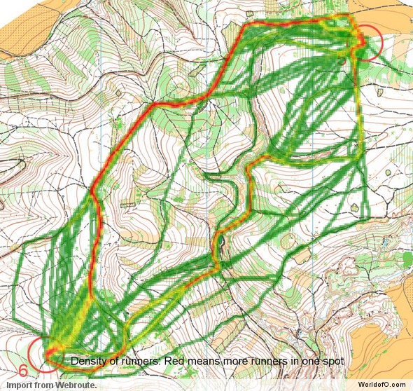
Todays leg in Route to Christmas from a hilly Czech terrain – giving interesting opportunities for the course planner. The chosen leg is leg number 11 in the H21E course from the Gigasport Èeský pohár organized at May 15th 2010.

Thanks a lot to Eva Jurenikova for sending in a tip about this leg! The leg is as usually first provided without routes – you may take a look at it and think about how you would attack this leg (if the image is too small, you may click on it to get it larger):

New: A giveaway for you!?

World of O reader Jan Palas won one edition of “O-Boka 2010″ a few days ago (on his birthday) – we have been lucky enough to be able to give away another free copy of the book (including shipping to wherever you live) to one of you who draws your suggested route for todays edition of ‘Route to Christmas’ in the Webroute below (remember to leave your e-mail address if you want to receive an email if drawn as a winner). “O-Boka 2010″ is a book in Norwegian language about the orienteering season 2010 including nearly 50 maps with routes (see review at OPN.no here). A nice book even if you don’t speak the language – and also a nice Christmas present.
For the record: This is a giveaway directly from the publisher to the readers of World of O as a service to the readers ; I do not receive any payment from the publisher. If you have a similar giveaway for the visitors for another day of Route to Christmas, please send an email to jan@kocbach.net with your suggestions.

Webroute

Next you can draw your own route using the ‘Webroute’ below. Think through how you would attack this leg, and draw the route you would have made. Some comments about why you would choose a certain route are always nice for the other readers.

Then you can take a look at how the runners who have drawn their route choice solved this leg. Although there are many possibilities to make big curves to save some altitude, it seems like the fastest option here (if you are strong enough) is to take all the hills directly – and keep quite close to the straight line based on the routes drawn. However, the one running the left route (Roman Zbranek) seems to have had a non-optimal route the last part into the control – in addition he is quite far behind the winner in the overall race. Thus I suspect that taking a left option might nevertheless be at least as fast as the direct route if the route is run well. If you run the race or have any further information about the leg – please add a comment below!

Complete map in Omaps.worldofo.com

You find the complete map and Routegadget info in omaps.worldofo.com at this location.

Omaps.worldofo.com

The ‘Route to Christmas’ series at World of O was very popular the last years – and I’ve therefore decided to continue the series this Christmas as well. If you have got any good legs in RouteGadget from 2010-competitions – or old forgotten ones which are still interesting – please email me the link at Jan@Kocbach.net, and I’ll include it in Route to Christmas if it looks good. Route to Christmas will not be interesting if YOU don’t contribute.

There will be no analysis about the best routechoice for each leg – you can provide that yourself in the comments or in the Webroute. Not all legs are taken for the interesting routechoice alternatives – some are also taken because the map is interesting – or because it is not straightforward to see what to do on a certain leg. Any comments are welcome – especially if you ran the event chosen for todays leg!

Note that there may be some errors in the Routegadget data (sometimes somebody draws a route for another runner just for fun). Please add a comment below if you spot en error.

Route to Christmas: Day 18 2010

Posted by Jan Kocbach, 18 Dec 2010@5:00

As Saturday is usually a quiet day here at World of O, we bring two legs in Route to Christmas today. Both are from the same competition in Switzerland in March this year – the second National competition. And we have some big names on the startlist – Fabian Hertner, Marc Lauenstein, Martin Hubmann and Andreas Kyburz.

Thanks a lot to Marcel Schiess for the suggestion! Thanks also to Martin Hubmann, Marc Lauenstein and Andreas Kyburz for drawing their routes on request.

- It was a tough competitions because the ground was softened by the rain. The slopes were very slippery, Martin Hubmann explains about the race.

The leg is as usually first provided without routes – you may take a look at it and think about how you would attack this leg (if the image is too small, you may click on it to get it larger):

Webroute

Next you can draw your own route using the ‘Webroute’ below. Think through how you would attack this leg, and draw the route you would have made. Some comments about why you would choose a certain route are always nice for the other readers.

Then you can take a look at how the runners who have drawn their route choice solved this leg. As you can see, there are two main choices: Either taking the rightmost route where you drop down a steep hill and have to run up again at the end of the leg – or take the upper left route which has less ascent but is somewhat longer. I’m quite sure I would have run left – and am surprised that so many took the right variant. It looks like the left is somewhat faster, but the difference is not big (Hertner might just have had a very fast day – BTW he was DNF in the end).

The second leg is leg number 26 in the same course. Even longer – even more challenging. What do you choose here?

Webroute

Next you can draw your own route using the ‘Webroute’ below. Think through how you would attack this leg, and draw the route you would have made. Some comments about why you would choose a certain route are always nice for the other readers.

Then you can take a look at how the runners who have drawn their route choice solved this leg. Here it looks like the direct choice was a “trap” from the course planner – all the best took the flatter road around.

Complete map in Omaps.worldofo.com

You find the complete map and Routegadget info in omaps.worldofo.com at this location.

“Fantasy World Cup” for Cross Country Skiing: La Clusaz Mass-start

Now for something completely different! World of O’s sister-site for cross country skiing, World of XC, is testing a Fantasy World Cup type competition where you are to try to predict the “Top 5″ in both the women’s and men’s class in the coming Cross Country Skiing World Cup race. You are invited to beta-test the WhoWins by dragging athletes from athlete-list on the left to your Top 5 list on the right below. This type of technical solution and scoring system is planned to be the basis for the Fantasy World Cup in Orienteering next year (more about the scoring system at the bottom of this page).

Race preview
The first mass-start event of the year – and the stage should normally be set for Petter Northug. Is his shape good enough in order to take the victory? To Norwegian journalists he said that he is not in top shape, but he does not have to be in top shape to win. A fight between Northug and Hellner is expected – but the Russians have been very strong lately, and Dario Cologna also wants to mix in ahead of Tour de Ski. And what about Markus Hellner and Lukas Bauer?

In the womens class, Bjørgen must be counted as the big favorite – probably the biggest favorite so far this year! She is skipping Tour de Ski, and wants to get her 42nd World Cup victory in this mass-start event (or 44th, depending on how you are counting). Other favorites among the women are Kowalczyk, Kalla and Follies. Saarinen might also mix in?

Some information about the race:

  • Start times: 13:15 CET for the women and 15:15 CET for the men
  • The course is not the greatest due to the snow conditions: It looks like each loop will be only 2.5 kilometers which the men will go 12(!) times – the women 6.

  • The German team is very thin: Axel Teichmann, Jens Filbrich, Franz Göring, Tom Reichel, Tobias Angerer, Evi Sachenbacher, Denise Herrmann and Nicole Fessel are all out on Saturday.
  • Kristin Størmer Steira is back after her injuries – can she fight for a place in the Top 5 again?
  • Petter Northug is back, but is said to have problems with the technique (Norwegian text)
  • Vincent Vittoz is still out with injury – very disappointed to not be able to race on homeground.
  • Astrid Jacobsen won her first World Cup victory on this distance (Norwegian text) – can she mix in on the Top 5? From her blog: – I did not really have a good day, but I managed to hang on to the tail of the field, and…
  • See teaser video for the races in La Clusaz

Route to Christmas: Day 17 2010

Posted by Jan Kocbach, 17 Dec 2010@5:00

Today’s leg in Route to Christmas is the longest so far. Yet again we visit Switzerland – the Swiss are among the very best both at using Routegadget and at sending suggestions about legs for Route to Christmas. It seems like it is no coincidence that Switzerland is the world’s best orienteering nation these days. Today’s route was provided by Andreas Kyburz.

- My club organized the TOM (Swiss Team Orienteering Championships) this November. There are 3 runners with only one SI card and you don’t have to run together). I was course setter and tried to create some routechoices, Kyburz wrote in his email – accompanied by a really long leg including some analysis about route lengths and ascent for the possible routechoices.

- Although it was a team competition, all runners said that they were running the hole leg alone. That means they did not change the SI card, Kyburz explained.

Thus the leg can be treated as any normal orienteering leg. The leg is as usually first provided without routes – you may take a look at it and think about how you would attack this leg (if the image is too small, you may click on it to get it larger):

Webroute

Next you can draw your own route using the ‘Webroute’ below. Think through how you would attack this leg, and draw the route you would have made. Some comments about why you would choose a certain route are always nice for the other readers.

Then you can take a look at how the top runners solved this leg. Thanks to Kyburz for providing a map with routes and times of all the top runners.

- I was indeed also a bit surprised about the small time differences, Kyburz comments. – I think, that the runners had quite the same speed and the runners who were a bit “slower” (than the best) took good routechoices (e.g. Martin Hubmann and Florian Howald).

What do you think? You may also take a look at the route lengths below the routes of the top runners. Results are available here.

Finally, the course planner has provided us with some data about the length of each route – along with the ascent:

A density map will be updated here when enough people have drawn their choice:
density_webroute_day17

Complete map in Omaps.worldofo.com

You find the complete map from Martin Hubmann’s team at omaps.worldofo.com at this location.

“Fantasy World Cup” for Cross Country Skiing: La Clusaz Mass-start

Now for something completely different! World of O’s sister-site for cross country skiing, World of XC, is testing a Fantasy World Cup type competition where you are to try to predict the “Top 5″ in both the women’s and men’s class in the coming Cross Country Skiing World Cup race. You are invited to beta-test the WhoWins by dragging athletes from athlete-list on the left to your Top 5 list on the right below. This type of technical solution and scoring system is planned to be the basis for the Fantasy World Cup in Orienteering next year (more about the scoring system at the bottom of this page).

Race preview
The first mass-start event of the year – and the stage should normally be set for Petter Northug. Is his shape good enough in order to take the victory? To Norwegian journalists he said that he is not in top shape, but he does not have to be in top shape to win. A fight between Northug and Hellner is expected – but the Russians have been very strong lately, and Dario Cologna also wants to mix in ahead of Tour de Ski. And what about Markus Hellner and Lukas Bauer?

In the womens class, Bjørgen must be counted as the big favorite – probably the biggest favorite so far this year! She is skipping Tour de Ski, and wants to get her 42nd World Cup victory in this mass-start event (or 44th, depending on how you are counting). Other favorites among the women are Kowalczyk, Kalla and Follies. Saarinen might also mix in?

Some information about the race:

  • Start times: 13:15 CET for the women and 15:15 CET for the men
  • The course is not the greatest due to the snow conditions: It looks like each loop will be only 2.5 kilometers which the men will go 12(!) times – the women 6.

  • The German team is very thin: Axel Teichmann, Jens Filbrich, Franz Göring, Tom Reichel, Tobias Angerer, Evi Sachenbacher, Denise Herrmann and Nicole Fessel are all out on Saturday.
  • Kristin Størmer Steira is back after her injuries – can she fight for a place in the Top 5 again?
  • Petter Northug is back, but is said to have problems with the technique (Norwegian text)
  • Vincent Vittoz is still out with injury – very disappointed to not be able to race on homeground.
  • Astrid Jacobsen won her first World Cup victory on this distance (Norwegian text) – can she mix in on the Top 5? From her blog: – I did not really have a good day, but I managed to hang on to the tail of the field, and…
  • See teaser video for the races in La Clusaz

Route to Christmas: Day 16 2010

Posted by Jan Kocbach, 16 Dec 2010@5:00

- I think that this leg is the best in any event I have run at in the past year. That was the first line in a very nice email which arrived in the mailbox yesterday evening. – It was at “Caw fell”, day 4 of the Lakes 5 Day event in England, Simon Bradbury continued. And indeed, it looks like a very nice leg – and was therefore chosen as the leg of the day for day 16 of Route to Christmas 2010.

Thanks a lot to Simon for the tip (we are still open for more!). The chosen leg is leg number 7 in course 3. There were similar legs in the longer courses, but course 3 was most interesting because more runners had drawn their routes. The leg is as usually first provided without routes – you may take a look at it and think about how you would attack this leg (if the image is too small, you may click on it to get it larger):

Webroute

Next you can draw your own route using the ‘Webroute’ below. Think through how you would attack this leg, and draw the route you would have made. Some comments about why you would choose a certain route are always nice for the other readers.

Then you can take a look at how the runners who have drawn their route choice solved this leg. Unfortunately not all the best runners have drawn their route – so it is a bit difficult to make a full conclusion based on the posted routes. Based on the strength of the runners, I would think that you would not loose much time by going around to either the left or the right. Compared to the average time in all of the race, Charlie Adams has lost some time on his route (dark blue,fastest time) even if he is 2 minutes faster than Nigel Bunn (light blue). I would say that Andrew Bradley’s route (red) could be a very good choice. But I wasn’t there – so please join in on the discussions below if you have any comments and/or knowledge about the competition.

Updated 16/12/2010 20:00 CET: Now we also have a density map ready to show which routes the visitors of World of O have chosen. Very few felt strong enough to run over the top – even if this was the fastest time of the day on this leg. Most have done as I would have done – going around at one of the sides of the hill.
density_webroute_day16

Complete map in Omaps.worldofo.com

You find the complete map and Routegadget info in omaps.worldofo.com at this location.

Omaps.worldofo.com

The ‘Route to Christmas’ series at World of O was very popular the last years – and I’ve therefore decided to continue the series this Christmas as well. If you have got any good legs in RouteGadget from 2010-competitions – or old forgotten ones which are still interesting – please email me the link at Jan@Kocbach.net, and I’ll include it in Route to Christmas if it looks good. Route to Christmas will not be interesting if YOU don’t contribute.

There will be no analysis about the best routechoice for each leg – you can provide that yourself in the comments or in the Webroute. Not all legs are taken for the interesting routechoice alternatives – some are also taken because the map is interesting – or because it is not straightforward to see what to do on a certain leg. Any comments are welcome – especially if you ran the event chosen for todays leg!

Note that there may be some errors in the Routegadget data (sometimes somebody draws a route for another runner just for fun). Please add a comment below if you spot en error.

Route to Christmas: Day 15 2010

Posted by Jan Kocbach, 15 Dec 2010@5:00

Today we are back to Switzerland for some hilly terrain in the Swiss test races this spring. The chosen event for today is the 4th National Swiss event of the year organized on May 9th 2010. There are interesting legs in several of the courses – but the category H18 is chosen as 16 runners(!) – including most of the top runners – have drawn their route in this category. That makes the routes & splits more representative – which again gives more fun for you.

Thanks a lot to Severin Howald for the tip! The leg is as usually first provided without routes – you may take a look at it and think about how you would attack this leg (if the image is too small, you may click on it to get it larger):

Webroute

Next you can draw your own route using the ‘Webroute’ below. Think through how you would attack this leg, and draw the route you would have made. Some comments about why you would choose a certain route are always nice for the other readers.

Then you can take a look at how the runners who have drawn their route choice solved this leg. As you can see, the routes taken by the top runners vary significantly. Fastest of all is Aschwanden who choose the lower variant – whereas Truttman choosing the upper variant is 10 seconds slower. The route which seems slowest is the more direct route which involves a lot of up and down.

Updated 15/12/2010 22:00 CET: Finally here is also the density map of the more than 200 people who have drawn their route. As you can see, quite a few went into the trap of taking a direct route – while most choose either the upper route or the lower route. Again: Thanks for all drawing their route!

density_webroute_day15

Complete map in Omaps.worldofo.com

You find the complete map and Routegadget info in omaps.worldofo.com at this location.

Giveaway winner day 14: Jan Palas!

We have been lucky enough to be able to give away a free copy of the book “O-Boka 2010″ (including shipping to wherever you live) to one drawing their route in yesterday’s edition of Route to Christmas. And the winner is Jan Palas! An email has been sent to Jan Palas. “O-Boka 2010″ is a book in Norwegian language about the orienteering season 2010 including nearly 50 maps with routes (see review at OPN.no here). A nice book even if you don’t speak the language – and also a nice Christmas present.
For the record: This is a giveaway directly from the publisher to the readers of World of O as a service to the readers ; I do not receive any payment from the publisher. If you have a similar giveaway for the visitors for another day of Route to Christmas, please send an email to jan@kocbach.net with your suggestions.

Omaps.worldofo.com

The ‘Route to Christmas’ series at World of O was very popular the last years – and I’ve therefore decided to continue the series this Christmas as well. If you have got any good legs in RouteGadget from 2010-competitions – or old forgotten ones which are still interesting – please email me the link at Jan@Kocbach.net, and I’ll include it in Route to Christmas if it looks good. Route to Christmas will not be interesting if YOU don’t contribute.

There will be no analysis about the best routechoice for each leg – you can provide that yourself in the comments or in the Webroute. Not all legs are taken for the interesting routechoice alternatives – some are also taken because the map is interesting – or because it is not straightforward to see what to do on a certain leg. Any comments are welcome – especially if you ran the event chosen for todays leg!

Note that there may be some errors in the Routegadget data (sometimes somebody draws a route for another runner just for fun). Please add a comment below if you spot en error.

Route to Christmas: Day 14 2010

Posted by Jan Kocbach, 14 Dec 2010@5:00

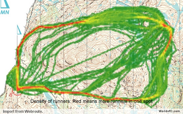
Todays leg in Route to Christmas is another long leg from Czech Republic. This actually looks like a training course, but it still has an interesting long leg for which many runners have drawn their route. The chosen leg is number 11 in a course which consists of some long legs with routechoice options and several control-picking parts in tricky, stony areas.

The training/competition was organized at April 4th 2010. If you know more about this training/competition, please add a comment below. Please don’t forget to tip about good candidates for Route to Christmas. I have only got a few good Routegadget-choices left (thanks to some tips from you) – and then I’ll have to go over to GPSSeuranta legs from Nordic terrain the last days until Christmas.

The leg is as usually first provided without routes – you may take a look at it and think about how you would attack this leg (if the image is too small, you may click on it to get it larger):

New: A giveaway for you!?

We have been lucky enough to be able to give away a free copy of the book “O-Boka 2010″ (including shipping to wherever you live) to one of you who draws your suggested route for todays edition of ‘Route to Christmas’ in the Webroute below (remember to leave your e-mail address if you want to receive an email if drawn as a winner). “O-Boka 2010″ is a book in Norwegian language about the orienteering season 2010 including nearly 50 maps with routes (see review at OPN.no here). A nice book even if you don’t speak the language – and also a nice Christmas present.
For the record: This is a giveaway directly from the publisher to the readers of World of O as a service to the readers ; I do not receive any payment from the publisher. If you have a similar giveaway for the visitors for another day of Route to Christmas, please send an email to jan@kocbach.net with your suggestions.

Webroute

Draw your own route using the ‘Webroute’ below. Think through how you would attack this leg, and draw the route you would have made. Some comments about why you would choose a certain route are always nice for the other readers.

Then you can take a look at how the runners who have drawn their route choice solved this leg. It looks like the two main choices – going around the big hill on the left or on the right – are approximately equal, although I might favor the right variant myself. What do you think? Add a comment – or wait for the density map this evening if you don’t want to speak up…

Below you see a density map based on who has drawn their route in the Webroute. A majority of the ones drawing their chosen route have found a variant to the right of the hill to be the best option – with two different options for the last part of the leg.

Complete map in Omaps.worldofo.com

You find the complete map and Routegadget info in omaps.worldofo.com at this location.

Omaps.worldofo.com

The ‘Route to Christmas’ series at World of O was very popular the last years – and I’ve therefore decided to continue the series this Christmas as well. If you have got any good legs in RouteGadget from 2010-competitions – or old forgotten ones which are still interesting – please email me the link at Jan@Kocbach.net, and I’ll include it in Route to Christmas if it looks good. Route to Christmas will not be interesting if YOU don’t contribute.

There will be no analysis about the best routechoice for each leg – you can provide that yourself in the comments or in the Webroute. Not all legs are taken for the interesting routechoice alternatives – some are also taken because the map is interesting – or because it is not straightforward to see what to do on a certain leg. Any comments are welcome – especially if you ran the event chosen for todays leg!

Note that there may be some errors in the Routegadget data (sometimes somebody draws a route for another runner just for fun). Please add a comment below if you spot en error.

Route to Christmas: Day 13 2010

Posted by Jan Kocbach, 13 Dec 2010@5:00

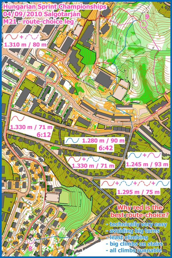
This very long leg from the Hungarian Sprint Championships has deserved its spot in the 2010 edition of Route to Christmas due to the many different route choice options and the complexity in finding the best route. The leg was suggested by the controller for the event – Aron Less. The event was held on September 4th in Salgótarján – and the 9th leg in the men’s a-final is the chosen leg. As many as 15 of the 24 starters have drawn their routes!

Thanks a lot to Aron Less for the tip – and also for providing his own analysis of the leg (see below). He also test-ran the route-choices on this particular leg. Course setter for the event – and the man behind this leg – was Dániel Pelyhe.

The leg is as usually first provided without routes – you may take a look at it and think about how you would attack this leg (if the image is too small, you may click on it to get it larger):

Webroute

Next you can draw your own route using the ‘Webroute’ below. Think through how you would attack this leg, and draw the route you would have made. Some comments about why you would choose a certain route are always nice for the other readers.

Then you can take a look at how the runners who have drawn their route choice solved this leg:

Then take a look at the analysis provided by Aron Less. As you can see both the splits of the runners and Less’s analysis confirms that the leftmost option is the best – and actually by as much as 30 seconds. The reason for this is that you avoid map-reading as it is technically very easy (make it easy), you avoid big turns (run straight lines), you avoid most of the climbing and all climbs are runnable.
ROBfinal_longroute_s

Finally, here is a density map showing which route was most popular among the ones drawing their route in the Webroute above. The version shown here is generated at December 13th 07:30 CET based on the first 17 people drawing their route – it will be updated this evening when more people have drawn their suggested routes (and thus be more informative then). This is the updated version with around 170 routes. As you can see, most have chosen the optimal route (did you cheat?) – except for the very first part of the leg.

Complete map in Omaps.worldofo.com

You find the complete map and Routegadget info in omaps.worldofo.com at this location.

Omaps.worldofo.com

The ‘Route to Christmas’ series at World of O was very popular the last years – and I’ve therefore decided to continue the series this Christmas as well. If you have got any good legs in RouteGadget from 2010-competitions – or old forgotten ones which are still interesting – please email me the link at Jan@Kocbach.net, and I’ll include it in Route to Christmas if it looks good. Route to Christmas will not be interesting if YOU don’t contribute.

There will be no analysis about the best routechoice for each leg – you can provide that yourself in the comments or in the Webroute. Not all legs are taken for the interesting routechoice alternatives – some are also taken because the map is interesting – or because it is not straightforward to see what to do on a certain leg. Any comments are welcome – especially if you ran the event chosen for todays leg!

Note that there may be some errors in the Routegadget data (sometimes somebody draws a route for another runner just for fun). Please add a comment below if you spot en error.

Route to Christmas: One step further?!

Posted by Jan Kocbach, 12 Dec 2010@18:00

density_webroute_232
Taking the Route to Christmas series one step further, I have now set up a way to analyze your thoughts about the optimal route on the legs presented in Route to Christmas. This is done through “density maps” in which one can easily see which route the orienteering community thinks is the best route on a leg based on all the routes drawn.

Above you see a density map from the Route to Christmas of today. The density map is made by identifying how many of you choose the different routes – visualized by a deep red color for many on a route green color for few. As you can see, most of the 120 drawing their route when this diagram was made choose a variant to the right, avoiding the big valley along the direct route. Also, quite a few choose variations of the direct route.  Most of the ones choosing the direct route run straight south out of the control down the path.

For your comparison, below is the routes chosen by selected runners in the competition in question.  Looking at the direct option, none of the runners in the competition for whom routes were drawn choose to follow the path south out of the control. The reason for this is probably that the white forest is so fast that it is better to cut through the forest than to take the path.

These density maps do of course not tell anything about which route is the fastest – but it is still interesting to see what people not familiar with the terrain think about the various choices. If you have any suggestions for further improvements, please add a comment below.

I have made similar density maps for all the days in Route to Christmas so far (see below). Note some have obviously had some fun drawing strange routes some days – they can easily be spotted in the illustrations below. Also, for some days the different routes are so spread out that it is difficult to see anything at all on the map. This is the kind of legs which are excellent from a spreading perspective – as the chances for group building is a lot reduced for this kind of legs. Enjoy!

Update! The idea to these density maps are partly based on an article on O-zeugs earlier this year, showing similar density maps based on Routegadget entries)

Route to Christmas 2010 – Day 1

See all information about this day of Route to Christmas here.

Route to Christmas 2010 – Day 2

See all information about this day of Route to Christmas here.

Route to Christmas 2010 – Day 3

See all information about this day of Route to Christmas here.

Route to Christmas 2010 – Day 4

See all information about this day of Route to Christmas here.

Route to Christmas 2010 – Day 5

See all information about this day of Route to Christmas here.

Route to Christmas 2010 – Day 6

See all information about this day of Route to Christmas here.

Route to Christmas 2010 – Day 7

See all information about this day of Route to Christmas here.

Route to Christmas 2010 – Day 8

See all information about this day of Route to Christmas here.

Route to Christmas 2010 – Day 9

See all information about this day of Route to Christmas here.

Route to Christmas 2010 – Day 10

See all information about this day of Route to Christmas here.

Route to Christmas 2010 – Day 11

See all information about this day of Route to Christmas here.

Route to Christmas: Day 12 2010

Posted by Jan Kocbach, 12 Dec 2010@5:00

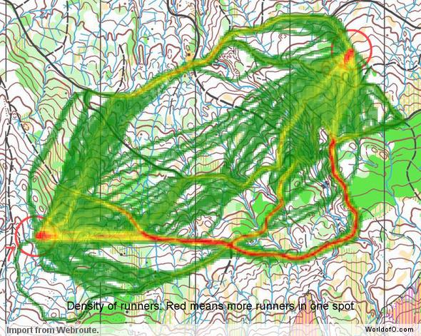
Todays leg in Route to Christmas is from Czech Republic – a long leg in hilly terrain. To pick a route on a long leg in this kind of terrain usually depends on how strong you are up the hills compared to running flat around. In addition there may be a lot of “micro” route-choice options on parts of the leg – this is were the leg is usually lost or won ; you have to keep up your concentration and do the correct choices all the way.

Today’s leg is from Mistrovství Moravy 2010 – the 6th leg in the competition organized at the 11th of April 2010 by KSU. The leg is as usually first provided without routes – you may take a look at it and think about how you would attack this leg (if the image is too small, you may click on it to get it larger):

Webroute

Next you can draw your own route using the ‘Webroute’ below. Think through how you would attack this leg, and draw the route you would have made. Some comments about why you would choose a certain route are always nice for the other readers.

Then you can take a look at how the runners who have drawn their route choice solved this leg (sorry for the problems with the Czech characters). Note that some of the best runners did not draw their route – the routes and times given here are based on the ones drawing their route in Routegadget. You can also look at the route from the complete course by Michal Besta from the competition here.

Looking at the splits, it looks like there is not much difference in time by chosing a direct variant compared to a right variant. Tomas Dlabaja has the best time of the runners drawing their route going straight – but Stipan Dlabaja is only 5 seconds slower going right. However, the direct route involves a lot more hill climbing, and thus for many it is probably wiser to save energy by going around to the right as the times are so similar. But I was not there – so I guess somebody who did actually run can fill out with further analysis in the comments below…

« Previous PageNext Page »